Myshkavichy geodata
Myshkavichy (Mogilev) is a populated place; located in Belarus in Europe/Minsk (GMT+3) time zone. With population of 2,000 people, there are 187 cities with bigger population in this country. Compared to other cities in Belarus, 70.4% of cities are located further ↑North; 74.3% of cities are located further ←West and 60.5% of cities have higher elevation than Myshkavichy. Note1


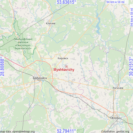
Myshkavichy GPS coordinates[2]
53° 13' 1.92" North, 29° 30' 43.2" East
| Map corner | latitude | longitude |
|---|---|---|
| Upper-left | 53.63615°, | 28.80888° |
| Center: | 53.2172°, | 29.512° |
| Lower-right: | 52.79411°, | 30.21513° |
| Map W x H: | 93.6×93.6 km | = 58.2×58.2mi |
| max Lat: | 56.0147° ⇑70.4% North |
| Myshkavichy: | 53.2172° |
| min Lat: | ⇓29.6% South 51.75° |
| min Long | Myshkavichy | max Long |
| 23.37083° | 29.512° | 32.578° |
| W 74.3%⇐ | ⇒25.7% E |
Elevation
Elevation of Myshkavichy is 157 m = 515 ft, and this is 11.6 m = 38 ft below average elevation for this country.
| Max E: |
309 m = 1014 ft | 60.5% |
| Avg. | 168.6 m = 553 ft | |
| Myshkavichy | 157 m = 515 ft | |
Min E: |
108 m = 354 ft | 39.5% |
See also: Belarus elevation on elevation.city.
Geographical zone
Myshkavichy is located in North temperate zone (between Tropic of Cancer and the Arctic Circle). Distance of this North polar circle is 1484 km =922.1 mi to North.| Distance of | km | miles | from Myshkavichy |
|---|---|---|---|
| North Pole | 4089.9 | 2541.3 | to North |
| Arctic Circle | 1484 | 922.1 | to North |
| Tropic Cancer | 3311.3 | 2057.5 | to South |
| Equator | 5917.2 | 3676.8 | to South |


Nearby cities:
15 places around Myshkavichy: (largest is in red/bold)
• Asipovichy
58.8 km =36.5 mi,  279°
279°
• Babruysk
21.3 km =13.2 mi,  245°
245°
• Bykhaw
59.2 km =36.8 mi,  55°
55°
• Dowsk
63.5 km =39.5 mi,  96°
96°
• Hlusha
46 km =28.6 mi, 251°
• Hlusk
65.4 km =40.6 mi,  237°
237°
• Kirawsk
6.3 km =3.9 mi,  337°
337°
• Klichaw
32.8 km =20.4 mi, 339°
• Krasnyy Bereg
47 km =29.2 mi,  74°
74°
• Parychy
46.4 km =28.8 mi,  187°
187°
• Rahachow
38.4 km =23.9 mi,  111°
111°
• Svyetlahorsk
66.7 km =41.4 mi,  166°
166°
• Tatarka
46.3 km =28.8 mi,  274°
274°
• Yalizava
39.3 km =24.4 mi,  301°
301°
• Zhlobin
49.7 km =30.9 mi,  136°
136°
Sources, notices
• [Note1] Compared only with cities in Belarus existing in our database
• [Src1] Map data: © OpenStreetMap contributors (CC-BY-SA)
• [Src2] Other city data from geonames.org with taken over terms of usage.
• [Src3] Geographical zone / Annual Mean Temperature by Robert A. Rohde @ Wikipedia
