Hlusha geodata
Hlusha (Mogilev) is a populated place; located in Belarus in Europe/Minsk (GMT+3) time zone. With population of 1,400 people, there are 216 cities with bigger population in this country. Compared to other cities in Belarus, 74.3% of cities are located further ↑North; 67.8% of cities are located further ←West and 53.6% of cities have lower elevation than Hlusha. Note1


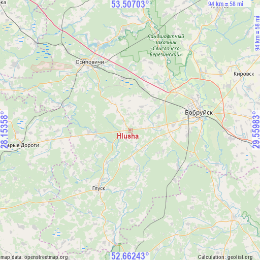
Hlusha GPS coordinates[2]
53° 5' 12.48" North, 28° 51' 24.12" East
| Map corner | latitude | longitude |
|---|---|---|
| Upper-left | 53.50703°, | 28.15358° |
| Center: | 53.0868°, | 28.8567° |
| Lower-right: | 52.66243°, | 29.55983° |
| Map W x H: | 93.9×93.9 km | = 58.3×58.3mi |
| max Lat: | 56.0147° ⇑74.3% North |
| Hlusha: | 53.0868° |
| min Lat: | ⇓25.7% South 51.75° |
| min Long | Hlusha | max Long |
| 23.37083° | 28.8567° | 32.578° |
| W 67.8%⇐ | ⇒32.2% E |
Elevation
Elevation of Hlusha is 169 m = 554 ft, and this is 0.40000000000001 m = 1 ft above average elevation for this country.
| Max E: |
309 m = 1014 ft | 46.4% |
| Hlusha | 169 m 554 ft | |
| Avg. | 168.6 m = 553 ft | |
Min E: |
108 m = 354 ft | 53.6% |
See also: Belarus elevation on elevation.city.
Geographical zone
Hlusha is located in North temperate zone (between Tropic of Cancer and the Arctic Circle). Distance of this North polar circle is 1498.5 km =931.1 mi to North.| Distance of | km | miles | from Hlusha |
|---|---|---|---|
| North Pole | 4104.4 | 2550.4 | to North |
| Arctic Circle | 1498.5 | 931.1 | to North |
| Tropic Cancer | 3296.8 | 2048.5 | to South |
| Equator | 5902.7 | 3667.8 | to South |


Nearby cities:
15 places around Hlusha: (largest is in red/bold)
• Aktsyabrski
49.3 km =30.6 mi,  178°
178°
• Asipovichy
27.9 km =17.3 mi,  328°
328°
• Babruysk
25 km =15.5 mi,  76°
76°
• Hlusk
23.5 km =14.6 mi,  209°
209°
• Kirawsk
45.9 km =28.5 mi,  63°
63°
• Klichaw
55.2 km =34.3 mi,  35°
35°
• Lyuban’
65.5 km =40.7 mi,  240°
240°
• Myshkavichy
46 km =28.6 mi,  71°
71°
• Parychy
49 km =30.4 mi,  129°
129°
• Pukhavichy
63.8 km =39.6 mi,  320°
320°
• Sarachy
65.3 km =40.6 mi, 239°
• Staryya Darohi
39.7 km =24.7 mi,  262°
262°
• Tatarka
18.7 km =11.6 mi,  352°
352°
• Urechcha
66.3 km =41.2 mi, 256°
• Yalizava
36.1 km =22.4 mi,  15°
15°
Sources, notices
• [Note1] Compared only with cities in Belarus existing in our database
• [Src1] Map data: © OpenStreetMap contributors (CC-BY-SA)
• [Src2] Other city data from geonames.org with taken over terms of usage.
• [Src3] Geographical zone / Annual Mean Temperature by Robert A. Rohde @ Wikipedia
