Kirawsk geodata
Kirawsk (Mogilev) is a seat of a second-order administrative division; located in Belarus in Europe/Minsk (GMT+3) time zone. With population of 8,700 people, there are 96 cities with bigger population in this country. Compared to other cities in Belarus, 68.4% of cities are located further ↑North; 73.7% of cities are located further ←West and 53% of cities have higher elevation than Kirawsk. Note1


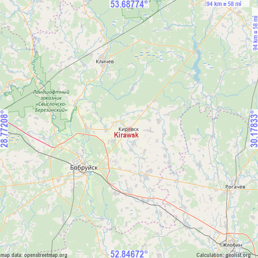
Kirawsk GPS coordinates[2]
53° 16' 9.48" North, 29° 28' 30.72" East
| Map corner | latitude | longitude |
|---|---|---|
| Upper-left | 53.68774°, | 28.77208° |
| Center: | 53.2693°, | 29.4752° |
| Lower-right: | 52.84672°, | 30.17833° |
| Map W x H: | 93.5×93.5 km | = 58.1×58.1mi |
| max Lat: | 56.0147° ⇑68.4% North |
| Kirawsk: | 53.2693° |
| min Lat: | ⇓31.6% South 51.75° |
| min Long | Kirawsk | max Long |
| 23.37083° | 29.4752° | 32.578° |
| W 73.7%⇐ | ⇒26.3% E |
Elevation
Elevation of Kirawsk is 162 m = 531 ft, and this is 6.6 m = 22 ft below average elevation for this country.
| Max E: |
309 m = 1014 ft | 53% |
| Avg. | 168.6 m = 553 ft | |
| Kirawsk | 162 m = 531 ft | |
Min E: |
108 m = 354 ft | 47% |
See also: Belarus elevation on elevation.city.
Geographical zone
Kirawsk is located in North temperate zone (between Tropic of Cancer and the Arctic Circle). Distance of this North polar circle is 1478.2 km =918.5 mi to North.| Distance of | km | miles | from Kirawsk |
|---|---|---|---|
| North Pole | 4084.1 | 2537.7 | to North |
| Arctic Circle | 1478.2 | 918.5 | to North |
| Tropic Cancer | 3317.1 | 2061.1 | to South |
| Equator | 5923 | 3680.4 | to South |


Nearby cities:
15 places around Kirawsk: (largest is in red/bold)
• Asipovichy
55.7 km =34.6 mi,  273°
273°
• Babruysk
22.3 km =13.9 mi,  229°
229°
• Bykhaw
58.2 km =36.2 mi,  61°
61°
• Dowsk
66.8 km =41.5 mi,  100°
100°
• Hlusha
45.9 km =28.5 mi,  243°
243°
• Hlusk
66.7 km =41.4 mi, 232°
• Klichaw
26.5 km =16.5 mi,  339°
339°
• Krasnyy Bereg
48.2 km =30 mi,  82°
82°
• Myshkavichy
6.3 km =3.9 mi,  157°
157°
• Pahost
67.9 km =42.2 mi, 341°
• Parychy
51.9 km =32.2 mi,  184°
184°
• Rahachow
43 km =26.7 mi,  117°
117°
• Tatarka
43.7 km =27.2 mi, 267°
• Yalizava
34.4 km =21.4 mi,  294°
294°
• Zhlobin
55.7 km =34.6 mi,  138°
138°
Sources, notices
• [Note1] Compared only with cities in Belarus existing in our database
• [Src1] Map data: © OpenStreetMap contributors (CC-BY-SA)
• [Src2] Other city data from geonames.org with taken over terms of usage.
• [Src3] Geographical zone / Annual Mean Temperature by Robert A. Rohde @ Wikipedia
