Amigo Beach geodata
Amigo Beach (Ontario) is a populated place; located in Canada in America/Toronto (GMT-4) time zone. With population of 1,545 people, there are 853 cities with bigger population in this country. Compared to other cities in Canada, 86.2% of cities are located further ↑North; 52.3% of cities are located further →East and 59.2% of cities have lower elevation than Amigo Beach. Note1


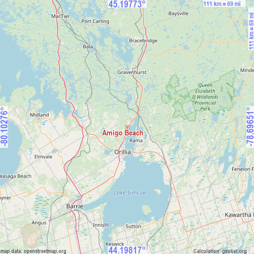
Amigo Beach GPS coordinates[2]
44° 42' 0.396" North, 79° 23' 58.668" West
| Map corner | latitude | longitude |
|---|---|---|
| Upper-left | 45.19773°, | -80.10276° |
| Center: | 44.70011°, | -79.39963° |
| Lower-right: | 44.19817°, | -78.69651° |
| Map W x H: | 111.1×111.1 km | = 69×69mi |
| max Lat: | 73.03752° ⇑86.2% North |
| Amigo Beach: | 44.70011° |
| min Lat: | ⇓13.8% South 42.05009° |
| min Long | Amigo Beach | max Long |
| -139.43328° | -79.39963° | -52.70931° |
| W 47.7%⇐ | ⇒52.3% E |
Elevation
Elevation of Amigo Beach is 228 m = 748 ft, and this is 26.4 m = 87 ft below average elevation for this country.
| Max E: |
1518 m = 4980 ft | 40.8% |
| Avg. | 254.4 m = 835 ft | |
| Amigo Beach | 228 m = 748 ft | |
Min E: |
-2 m = -7 ft | 59.2% |
See also: Canada elevation on elevation.city.
Geographical zone
Amigo Beach is located in North temperate zone (between Tropic of Cancer and the Arctic Circle). Distance of this Northern Tropic circle is 2364.3 km =1469.1 mi to South.| Distance of | km | miles | from Amigo Beach |
|---|---|---|---|
| North Pole | 5036.9 | 3129.8 | to North |
| Arctic Circle | 2431 | 1510.6 | to North |
| Tropic Cancer | 2364.3 | 1469.1 | to South |
| Equator | 4970.2 | 3088.3 | to South |


Nearby cities:
15 places around Amigo Beach: (largest is in red/bold)
• Angus
57.3 km =35.6 mi,  221°
221°
• Anten Mills
41 km =25.5 mi,  233°
233°
• Barrie
39.5 km =24.5 mi,  212°
212°
• Bracebridge
37.6 km =23.4 mi,  10°
10°
• Cookstown
62.2 km =38.6 mi,  202°
202°
• Elmvale
39.1 km =24.3 mi,  250°
250°
• Gravenhurst
24.2 km =15 mi, 6°
• Innisfil
48.7 km =30.3 mi, 204°
• Keswick
50.3 km =31.3 mi,  186°
186°
• Midland
38.6 km =24 mi,  278°
278°
• Orillia
10.3 km =6.4 mi, 189°
• Patrick Fogarty Catholic Secondary School
8.7 km =5.4 mi, 196°
• Stoney Point
49.3 km =30.6 mi, 192°
• Wasaga Beach
52.9 km =32.9 mi, 247°
• Zephyr
56.6 km =35.2 mi,  169°
169°
Sources, notices
• [Note1] Compared only with cities in Canada existing in our database
• [Src1] Map data: © OpenStreetMap contributors (CC-BY-SA)
• [Src2] Other city data from geonames.org with taken over terms of usage.
• [Src3] Geographical zone / Annual Mean Temperature by Robert A. Rohde @ Wikipedia
