Anten Mills geodata
Anten Mills (Ontario) is a populated place; located in Canada in America/Toronto (GMT-4) time zone. With population of 800 people, there are 1101 cities with bigger population in this country. Compared to other cities in Canada, 87.7% of cities are located further ↑North; 54.5% of cities are located further →East and 60.1% of cities have lower elevation than Anten Mills. Note1


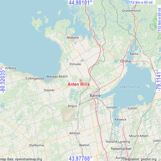
Anten Mills GPS coordinates[2]
44° 28' 53.4" North, 79° 49' 1.992" West
| Map corner | latitude | longitude |
|---|---|---|
| Upper-left | 44.98101°, | -80.52035° |
| Center: | 44.4815°, | -79.81722° |
| Lower-right: | 43.97768°, | -79.1141° |
| Map W x H: | 111.6×111.6 km | = 69.3×69.3mi |
| max Lat: | 73.03752° ⇑87.7% North |
| Anten Mills: | 44.4815° |
| min Lat: | ⇓12.3% South 42.05009° |
| min Long | Anten Mills | max Long |
| -139.43328° | -79.81722° | -52.70931° |
| W 45.5%⇐ | ⇒54.5% E |
Elevation
Elevation of Anten Mills is 233 m = 764 ft, and this is 21.4 m = 70 ft below average elevation for this country.
| Max E: |
1518 m = 4980 ft | 39.9% |
| Avg. | 254.4 m = 835 ft | |
| Anten Mills | 233 m = 764 ft | |
Min E: |
-2 m = -7 ft | 60.1% |
See also: Canada elevation on elevation.city.
Geographical zone
Anten Mills is located in North temperate zone (between Tropic of Cancer and the Arctic Circle). Distance of this Northern Tropic circle is 2340 km =1454 mi to South.| Distance of | km | miles | from Anten Mills |
|---|---|---|---|
| North Pole | 5061.2 | 3144.9 | to North |
| Arctic Circle | 2455.3 | 1525.7 | to North |
| Tropic Cancer | 2340 | 1454 | to South |
| Equator | 4945.9 | 3073.2 | to South |


Nearby cities:
15 places around Anten Mills: (largest is in red/bold)
• Alliston
37.1 km =23.1 mi,  186°
186°
• Amigo Beach
41 km =25.5 mi,  53°
53°
• Angus
19 km =11.8 mi,  195°
195°
• Barrie
15 km =9.3 mi,  127°
127°
• Collingwood
31.7 km =19.7 mi,  270°
270°
• Cookstown
34.4 km =21.4 mi,  164°
164°
• Elmvale
12 km =7.5 mi,  341°
341°
• Innisfil
24.2 km =15 mi,  146°
146°
• Keswick
37.9 km =23.5 mi, 132°
• Midland
30.3 km =18.8 mi,  350°
350°
• Orillia
34.5 km =21.4 mi,  65°
65°
• Patrick Fogarty Catholic Secondary School
34.5 km =21.4 mi,  62°
62°
• Stoney Point
32.9 km =20.4 mi,  136°
136°
• Tottenham
50.8 km =31.6 mi,  178°
178°
• Wasaga Beach
16.3 km =10.1 mi,  283°
283°
Sources, notices
• [Note1] Compared only with cities in Canada existing in our database
• [Src1] Map data: © OpenStreetMap contributors (CC-BY-SA)
• [Src2] Other city data from geonames.org with taken over terms of usage.
• [Src3] Geographical zone / Annual Mean Temperature by Robert A. Rohde @ Wikipedia
