Orillia geodata
Orillia (Ontario) is a populated place; located in Canada in America/Toronto (GMT-4) time zone. With population of 30,178 people, there are 146 cities with bigger population in this country. Compared to other cities in Canada, 87% of cities are located further ↑North; 52.5% of cities are located further →East and 59.8% of cities have lower elevation than Orillia. Note1


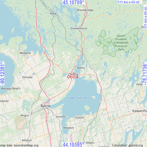
Orillia GPS coordinates[2]
44° 36' 31.248" North, 79° 25' 14.448" West
| Map corner | latitude | longitude |
|---|---|---|
| Upper-left | 45.10709°, | -80.12381° |
| Center: | 44.60868°, | -79.42068° |
| Lower-right: | 44.10595°, | -78.71756° |
| Map W x H: | 111.3×111.3 km | = 69.2×69.2mi |
| max Lat: | 73.03752° ⇑87% North |
| Orillia: | 44.60868° |
| min Lat: | ⇓13% South 42.05009° |
| min Long | Orillia | max Long |
| -139.43328° | -79.42068° | -52.70931° |
| W 47.5%⇐ | ⇒52.5% E |
Elevation
Elevation of Orillia is 232 m = 761 ft, and this is 22.4 m = 73 ft below average elevation for this country.
| Max E: |
1518 m = 4980 ft | 40.2% |
| Avg. | 254.4 m = 835 ft | |
| Orillia | 232 m = 761 ft | |
Min E: |
-2 m = -7 ft | 59.8% |
See also: Canada elevation on elevation.city.
Geographical zone
Orillia is located in North temperate zone (between Tropic of Cancer and the Arctic Circle). Distance of this Northern Tropic circle is 2354.1 km =1462.8 mi to South.| Distance of | km | miles | from Orillia |
|---|---|---|---|
| North Pole | 5047 | 3136.1 | to North |
| Arctic Circle | 2441.2 | 1516.9 | to North |
| Tropic Cancer | 2354.1 | 1462.8 | to South |
| Equator | 4960 | 3082 | to South |


Nearby cities:
15 places around Orillia: (largest is in red/bold)
• Amigo Beach
10.3 km =6.4 mi,  9°
9°
• Angus
49 km =30.4 mi,  228°
228°
• Anten Mills
34.5 km =21.4 mi,  245°
245°
• Barrie
30.3 km =18.8 mi,  220°
220°
• Bracebridge
47.9 km =29.8 mi, 9°
• Cookstown
52.2 km =32.4 mi,  205°
205°
• Elmvale
35.4 km =22 mi,  265°
265°
• Gravenhurst
34.5 km =21.4 mi, 7°
• Innisfil
38.8 km =24.1 mi, 207°
• Keswick
40 km =24.9 mi,  185°
185°
• Midland
39.8 km =24.7 mi,  293°
293°
• Patrick Fogarty Catholic Secondary School
2 km =1.2 mi,  336°
336°
• Stoney Point
39 km =24.2 mi, 193°
• Wasaga Beach
48.3 km =30 mi,  257°
257°
• Zephyr
47.1 km =29.3 mi,  164°
164°
Sources, notices
• [Note1] Compared only with cities in Canada existing in our database
• [Src1] Map data: © OpenStreetMap contributors (CC-BY-SA)
• [Src2] Other city data from geonames.org with taken over terms of usage.
• [Src3] Geographical zone / Annual Mean Temperature by Robert A. Rohde @ Wikipedia
