Bracebridge geodata
Bracebridge (Ontario) is a populated place; located in Canada in America/Toronto (GMT-4) time zone. With population of 8,238 people, there are 355 cities with bigger population in this country. Compared to other cities in Canada, 84.5% of cities are located further ↑North; 51.7% of cities are located further →East and 61.7% of cities have lower elevation than Bracebridge. Note1


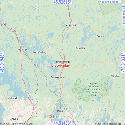
Bracebridge GPS coordinates[2]
45° 2' 0.276" North, 79° 18' 58.788" West
| Map corner | latitude | longitude |
|---|---|---|
| Upper-left | 45.52815°, | -80.01946° |
| Center: | 45.03341°, | -79.31633° |
| Lower-right: | 44.53436°, | -78.61321° |
| Map W x H: | 110.5×110.5 km | = 68.7×68.7mi |
| max Lat: | 73.03752° ⇑84.5% North |
| Bracebridge: | 45.03341° |
| min Lat: | ⇓15.5% South 42.05009° |
| min Long | Bracebridge | max Long |
| -139.43328° | -79.31633° | -52.70931° |
| W 48.3%⇐ | ⇒51.7% E |
Elevation
Elevation of Bracebridge is 240 m = 787 ft, and this is 14.4 m = 47 ft below average elevation for this country.
| Max E: |
1518 m = 4980 ft | 38.3% |
| Avg. | 254.4 m = 835 ft | |
| Bracebridge | 240 m = 787 ft | |
Min E: |
-2 m = -7 ft | 61.7% |
See also: Canada elevation on elevation.city.
Geographical zone
Bracebridge is located in North temperate zone (between Tropic of Cancer and the Arctic Circle). Distance of this North polar circle is 2393.9 km =1487.5 mi to North.| Distance of | km | miles | from Bracebridge |
|---|---|---|---|
| North Pole | 4999.8 | 3106.7 | to North |
| Arctic Circle | 2393.9 | 1487.5 | to North |
| Tropic Cancer | 2401.3 | 1492.1 | to South |
| Equator | 5007.2 | 3111.3 | to South |


Nearby cities:
15 places around Bracebridge: (largest is in red/bold)
• Amigo Beach
37.6 km =23.4 mi,  190°
190°
• Anten Mills
73 km =45.4 mi,  212°
212°
• Barrie
75.7 km =47 mi,  201°
201°
• Elmvale
66.2 km =41.1 mi,  220°
220°
• Gravenhurst
13.5 km =8.4 mi, 196°
• Haliburton Village
62.4 km =38.8 mi,  88°
88°
• Huntsville
34.3 km =21.3 mi,  13°
13°
• Innisfil
85.7 km =53.3 mi, 197°
• Keswick
87.9 km =54.6 mi, 187°
• Midland
54.6 km =33.9 mi,  234°
234°
• Orillia
47.9 km =29.8 mi, 189°
• Parry Sound
66.3 km =41.2 mi,  301°
301°
• Patrick Fogarty Catholic Secondary School
46.2 km =28.7 mi, 191°
• Stoney Point
86.9 km =54 mi, 191°
• Wasaga Beach
79.7 km =49.5 mi, 223°
Sources, notices
• [Note1] Compared only with cities in Canada existing in our database
• [Src1] Map data: © OpenStreetMap contributors (CC-BY-SA)
• [Src2] Other city data from geonames.org with taken over terms of usage.
• [Src3] Geographical zone / Annual Mean Temperature by Robert A. Rohde @ Wikipedia
