Alliston geodata
Alliston (Ontario) is a populated place; located in Canada in America/Toronto (GMT-4) time zone. With population of 18,809 people, there are 196 cities with bigger population in this country. Compared to other cities in Canada, 90.6% of cities are located further ↑North; 54.8% of cities are located further →East and 58.8% of cities have lower elevation than Alliston. Note1


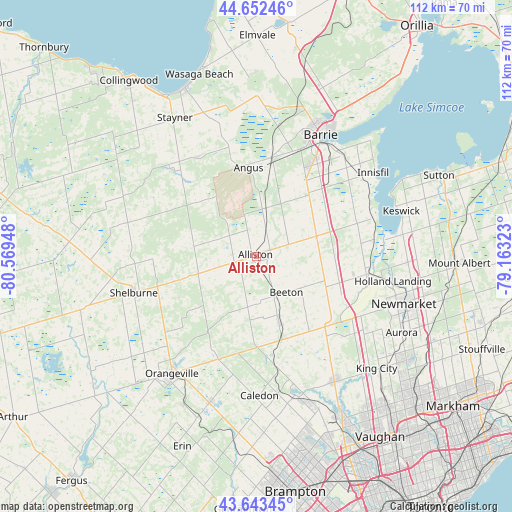
Alliston GPS coordinates[2]
44° 9' 0.396" North, 79° 51' 58.86" West
| Map corner | latitude | longitude |
|---|---|---|
| Upper-left | 44.65246°, | -80.56948° |
| Center: | 44.15011°, | -79.86635° |
| Lower-right: | 43.64345°, | -79.16323° |
| Map W x H: | 112.2×112.2 km | = 69.7×69.7mi |
| max Lat: | 73.03752° ⇑90.6% North |
| Alliston: | 44.15011° |
| min Lat: | ⇓9.4% South 42.05009° |
| min Long | Alliston | max Long |
| -139.43328° | -79.86635° | -52.70931° |
| W 45.2%⇐ | ⇒54.8% E |
Elevation
Elevation of Alliston is 223 m = 732 ft, and this is 31.4 m = 103 ft below average elevation for this country.
| Max E: |
1518 m = 4980 ft | 41.2% |
| Avg. | 254.4 m = 835 ft | |
| Alliston | 223 m = 732 ft | |
Min E: |
-2 m = -7 ft | 58.8% |
See also: Canada elevation on elevation.city.
Geographical zone
Alliston is located in North temperate zone (between Tropic of Cancer and the Arctic Circle). Distance of this Northern Tropic circle is 2303.1 km =1431.1 mi to South.| Distance of | km | miles | from Alliston |
|---|---|---|---|
| North Pole | 5098 | 3167.7 | to North |
| Arctic Circle | 2492.1 | 1548.5 | to North |
| Tropic Cancer | 2303.1 | 1431.1 | to South |
| Equator | 4909 | 3050.3 | to South |


Nearby cities:
15 places around Alliston: (largest is in red/bold)
• Angus
18.6 km =11.6 mi,  355°
355°
• Anten Mills
37.1 km =23.1 mi,  6°
6°
• Aurora
36 km =22.4 mi,  117°
117°
• Barrie
32 km =19.9 mi,  29°
29°
• Cookstown
13.8 km =8.6 mi,  74°
74°
• East Gwillimbury
34.6 km =21.5 mi,  99°
99°
• Innisfil
24 km =14.9 mi,  45°
45°
• Keswick
33.8 km =21 mi, 70°
• King
30.2 km =18.8 mi,  132°
132°
• Newmarket
33.8 km =21 mi,  109°
109°
• Orangeville
32 km =19.9 mi,  215°
215°
• Shelburne
28.1 km =17.5 mi,  253°
253°
• Stoney Point
29.6 km =18.4 mi,  63°
63°
• Tottenham
14.8 km =9.2 mi,  160°
160°
• Wasaga Beach
42.5 km =26.4 mi,  343°
343°
Sources, notices
• [Note1] Compared only with cities in Canada existing in our database
• [Src1] Map data: © OpenStreetMap contributors (CC-BY-SA)
• [Src2] Other city data from geonames.org with taken over terms of usage.
• [Src3] Geographical zone / Annual Mean Temperature by Robert A. Rohde @ Wikipedia
