Tottenham geodata
Tottenham (Ontario) is a populated place; located in Canada in America/Toronto (GMT-4) time zone. With population of 5,143 people, there are 469 cities with bigger population in this country. Compared to other cities in Canada, 91.6% of cities are located further ↑North; 54.4% of cities are located further →East and 63.4% of cities have lower elevation than Tottenham. Note1


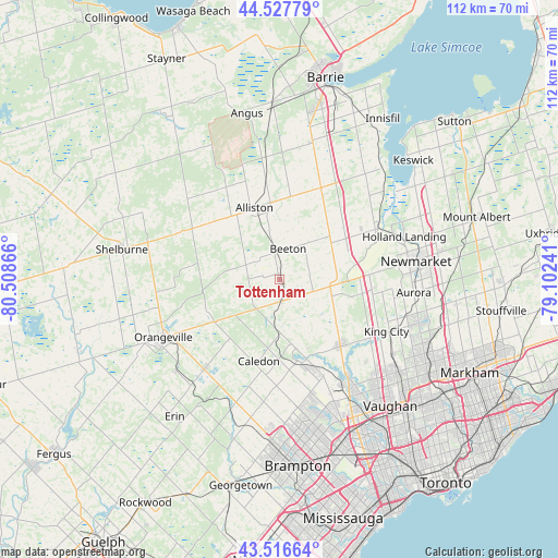
Tottenham GPS coordinates[2]
44° 1' 27.732" North, 79° 48' 19.908" West
| Map corner | latitude | longitude |
|---|---|---|
| Upper-left | 44.52779°, | -80.50866° |
| Center: | 44.02437°, | -79.80553° |
| Lower-right: | 43.51664°, | -79.10241° |
| Map W x H: | 112.4×112.4 km | = 69.8×69.8mi |
| max Lat: | 73.03752° ⇑91.6% North |
| Tottenham: | 44.02437° |
| min Lat: | ⇓8.4% South 42.05009° |
| min Long | Tottenham | max Long |
| -139.43328° | -79.80553° | -52.70931° |
| W 45.6%⇐ | ⇒54.4% E |
Elevation
Elevation of Tottenham is 247 m = 810 ft, and this is 7.4 m = 24 ft below average elevation for this country.
| Max E: |
1518 m = 4980 ft | 36.6% |
| Avg. | 254.4 m = 835 ft | |
| Tottenham | 247 m = 810 ft | |
Min E: |
-2 m = -7 ft | 63.4% |
See also: Canada elevation on elevation.city.
Geographical zone
Tottenham is located in North temperate zone (between Tropic of Cancer and the Arctic Circle). Distance of this Northern Tropic circle is 2289.1 km =1422.4 mi to South.| Distance of | km | miles | from Tottenham |
|---|---|---|---|
| North Pole | 5112 | 3176.4 | to North |
| Arctic Circle | 2506.1 | 1557.2 | to North |
| Tropic Cancer | 2289.1 | 1422.4 | to South |
| Equator | 4895.1 | 3041.7 | to South |


Nearby cities:
15 places around Tottenham: (largest is in red/bold)
• Alliston
14.8 km =9.2 mi,  340°
340°
• Angus
33.1 km =20.6 mi,  349°
349°
• Aurora
27.3 km =17 mi,  95°
95°
• Concord
35.9 km =22.3 mi,  133°
133°
• Cookstown
19.6 km =12.2 mi,  25°
25°
• East Gwillimbury
30.6 km =19 mi,  73°
73°
• Innisfil
33.1 km =20.6 mi,  22°
22°
• Keswick
36.9 km =22.9 mi,  47°
47°
• King
18.4 km =11.4 mi,  110°
110°
• Newmarket
27.3 km =17 mi,  83°
83°
• Orangeville
26.4 km =16.4 mi,  243°
243°
• Richmond Hill
34.1 km =21.2 mi,  120°
120°
• Shelburne
32.4 km =20.1 mi,  280°
280°
• Stoney Point
34.6 km =21.5 mi,  38°
38°
• Vaughan
32.3 km =20.1 mi, 130°
Sources, notices
• [Note1] Compared only with cities in Canada existing in our database
• [Src1] Map data: © OpenStreetMap contributors (CC-BY-SA)
• [Src2] Other city data from geonames.org with taken over terms of usage.
• [Src3] Geographical zone / Annual Mean Temperature by Robert A. Rohde @ Wikipedia
