Smoky Lake geodata
Smoky Lake (Alberta) is a populated place; located in Canada in America/Edmonton (GMT-6) time zone. With population of 1,063 people, there are 1017 cities with bigger population in this country. Compared to other cities in Canada, 93.4% of cities are located further ↓South; 76.9% of cities are located further →East and 87.6% of cities have lower elevation than Smoky Lake. Note1


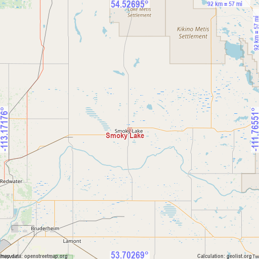
Smoky Lake GPS coordinates[2]
54° 7' 0.732" North, 112° 28' 7.068" West
| Map corner | latitude | longitude |
|---|---|---|
| Upper-left | 54.52695°, | -113.17176° |
| Center: | 54.11687°, | -112.46863° |
| Lower-right: | 53.70269°, | -111.76551° |
| Map W x H: | 91.6×91.6 km | = 56.9×56.9mi |
| max Lat: | 73.03752° ⇑6.6% North |
| Smoky Lake: | 54.11687° |
| min Lat: | ⇓93.4% South 42.05009° |
| min Long | Smoky Lake | max Long |
| -139.43328° | -112.46863° | -52.70931° |
| W 23.1%⇐ | ⇒76.9% E |
Elevation
Elevation of Smoky Lake is 618 m = 2028 ft, and this is 363.6 m = 1193 ft above average elevation for this country.
| Max E: |
1518 m = 4980 ft | 12.4% |
| Smoky Lake | 618 m 2028 ft | |
| Avg. | 254.4 m = 835 ft | |
Min E: |
-2 m = -7 ft | 87.6% |
See also: Canada elevation on elevation.city.
Geographical zone
Smoky Lake is located in North temperate zone (between Tropic of Cancer and the Arctic Circle). Distance of this North polar circle is 1383.9 km =859.9 mi to North.| Distance of | km | miles | from Smoky Lake |
|---|---|---|---|
| North Pole | 3989.8 | 2479.1 | to North |
| Arctic Circle | 1383.9 | 859.9 | to North |
| Tropic Cancer | 3411.3 | 2119.7 | to South |
| Equator | 6017.2 | 3738.9 | to South |


Nearby cities:
15 places around Smoky Lake: (largest is in red/bold)
• Athabasca
85.1 km =52.9 mi,  321°
321°
• Bon Accord
69.7 km =43.3 mi,  243°
243°
• Edmonton
91 km =56.5 mi,  226°
226°
• Fort Saskatchewan
66.3 km =41.2 mi, 227°
• Gibbons
64.8 km =40.3 mi, 240°
• Lac La Biche
79.2 km =49.2 mi,  24°
24°
• Lamont
44.6 km =27.7 mi,  209°
209°
• Maple Ridge
90.1 km =56 mi,  220°
220°
• Morinville
85.1 km =52.9 mi,  245°
245°
• Sherwood Park
87 km =54.1 mi, 219°
• St. Paul
78.7 km =48.9 mi,  100°
100°
• Tofield
84.4 km =52.4 mi,  188°
188°
• Two Hills
64.7 km =40.2 mi,  133°
133°
• Vegreville
73.8 km =45.9 mi,  158°
158°
• Westlock
91.3 km =56.7 mi,  272°
272°
Sources, notices
• [Note1] Compared only with cities in Canada existing in our database
• [Src1] Map data: © OpenStreetMap contributors (CC-BY-SA)
• [Src2] Other city data from geonames.org with taken over terms of usage.
• [Src3] Geographical zone / Annual Mean Temperature by Robert A. Rohde @ Wikipedia
