Lamont geodata
Lamont (Alberta) is a populated place; located in Canada in America/Edmonton (GMT-6) time zone. With population of 1,779 people, there are 796 cities with bigger population in this country. Compared to other cities in Canada, 92.4% of cities are located further ↓South; 77.4% of cities are located further →East and 88.6% of cities have lower elevation than Lamont. Note1


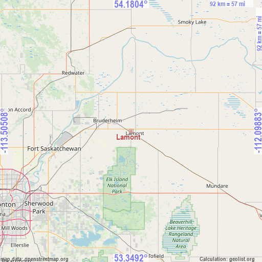
Lamont GPS coordinates[2]
53° 46' 0.696" North, 112° 48' 7.02" West
| Map corner | latitude | longitude |
|---|---|---|
| Upper-left | 54.1804°, | -113.50508° |
| Center: | 53.76686°, | -112.80195° |
| Lower-right: | 53.3492°, | -112.09883° |
| Map W x H: | 92.4×92.4 km | = 57.4×57.4mi |
| max Lat: | 73.03752° ⇑7.6% North |
| Lamont: | 53.76686° |
| min Lat: | ⇓92.4% South 42.05009° |
| min Long | Lamont | max Long |
| -139.43328° | -112.80195° | -52.70931° |
| W 22.6%⇐ | ⇒77.4% E |
Elevation
Elevation of Lamont is 643 m = 2110 ft, and this is 388.6 m = 1275 ft above average elevation for this country.
| Max E: |
1518 m = 4980 ft | 11.4% |
| Lamont | 643 m 2110 ft | |
| Avg. | 254.4 m = 835 ft | |
Min E: |
-2 m = -7 ft | 88.6% |
See also: Canada elevation on elevation.city.
Geographical zone
Lamont is located in North temperate zone (between Tropic of Cancer and the Arctic Circle). Distance of this North polar circle is 1422.9 km =884.1 mi to North.| Distance of | km | miles | from Lamont |
|---|---|---|---|
| North Pole | 4028.7 | 2503.3 | to North |
| Arctic Circle | 1422.9 | 884.1 | to North |
| Tropic Cancer | 3372.4 | 2095.5 | to South |
| Equator | 5978.3 | 3714.7 | to South |


Nearby cities:
15 places around Lamont: (largest is in red/bold)
• Bon Accord
41.2 km =25.6 mi,  280°
280°
• Edmonton
50.1 km =31.1 mi,  241°
241°
• Fort Saskatchewan
28 km =17.4 mi,  258°
258°
• Gibbons
35.8 km =22.2 mi, 281°
• Larkspur
49.8 km =30.9 mi,  230°
230°
• Laurel
52.3 km =32.5 mi, 227°
• Maple Ridge
47.3 km =29.4 mi, 231°
• Mill Woods Town Centre
53.8 km =33.4 mi, 230°
• Morinville
56 km =34.8 mi,  273°
273°
• Sherwood Park
44 km =27.3 mi, 230°
• Silver Berry
51.4 km =31.9 mi, 228°
• Smoky Lake
44.6 km =27.7 mi,  29°
29°
• Tamarack
50 km =31.1 mi, 227°
• Tofield
45.3 km =28.1 mi,  168°
168°
• Wild Rose
50.4 km =31.3 mi, 229°
Sources, notices
• [Note1] Compared only with cities in Canada existing in our database
• [Src1] Map data: © OpenStreetMap contributors (CC-BY-SA)
• [Src2] Other city data from geonames.org with taken over terms of usage.
• [Src3] Geographical zone / Annual Mean Temperature by Robert A. Rohde @ Wikipedia
