Saint-Léonard geodata
Saint-Léonard (Quebec) is a section of populated place; located in Canada in America/Toronto (GMT-4) time zone. With population of 73,423 people, there are 76 cities with bigger population in this country. Compared to other cities in Canada, 72.2% of cities are located further ↑North; 67% of cities are located further ←West and 74.8% of cities have higher elevation than Saint-Léonard. Note1
Administrative division(s):
- Level 1: Quebec
- Level 2: Montréal
- Level 3: Montréal
- Level 4: Saint-Léonard


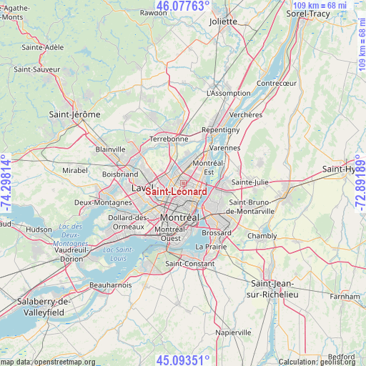
Saint-Léonard GPS coordinates[2]
45° 35' 15.828" North, 73° 35' 42.036" West
| Map corner | latitude | longitude |
|---|---|---|
| Upper-left | 46.07763°, | -74.29814° |
| Center: | 45.58773°, | -73.59501° |
| Lower-right: | 45.09351°, | -72.89189° |
| Map W x H: | 109.4×109.4 km | = 68×68mi |
| max Lat: | 73.03752° ⇑72.2% North |
| Saint-Léonard: | 45.58773° |
| min Lat: | ⇓27.8% South 42.05009° |
| min Long | Saint-Léonard | max Long |
| -139.43328° | -73.59501° | -52.70931° |
| W 67%⇐ | ⇒33% E |
Elevation
Elevation of Saint-Léonard is 43 m = 141 ft, and this is 211.4 m = 694 ft below average elevation for this country.
| Max E: |
1518 m = 4980 ft | 74.8% |
| Avg. | 254.4 m = 835 ft | |
| Saint-Léonard | 43 m = 141 ft | |
Min E: |
-2 m = -7 ft | 25.2% |
See also: Saint-Léonard elevation on elevation.city.
Geographical zone
Saint-Léonard is located in North temperate zone (between Tropic of Cancer and the Arctic Circle). Distance of this North polar circle is 2332.3 km =1449.2 mi to North.| Distance of | km | miles | from Saint-Léonard |
|---|---|---|---|
| North Pole | 4938.2 | 3068.5 | to North |
| Arctic Circle | 2332.3 | 1449.2 | to North |
| Tropic Cancer | 2463 | 1530.4 | to South |
| Equator | 5068.9 | 3149.7 | to South |


Nearby cities:
15 places around Saint-Léonard: (largest is in red/bold)
• Boucherville
12.4 km =7.7 mi,  88°
88°
• Hampstead
13 km =8.1 mi,  203°
203°
• Laval
7.8 km =4.8 mi,  255°
255°
• Longueuil
8.7 km =5.4 mi,  136°
136°
• Mont-Royal
8.9 km =5.5 mi,  208°
208°
• Montréal
8.8 km =5.5 mi,  176°
176°
• Montréal-Est
8.4 km =5.2 mi,  54°
54°
• Notre-Dame-de-Grâce
12.4 km =7.7 mi,  186°
186°
• Saint-Charles
13.2 km =8.2 mi,  13°
13°
• Saint-Elzéar
10.4 km =6.5 mi,  279°
279°
• Saint-Laurent
11.2 km =7 mi, 209°
• Saint-Michel
3.1 km =1.9 mi,  222°
222°
• Saint-Victor
6.7 km =4.2 mi,  67°
67°
• Terrebonne
13.1 km =8.1 mi,  341°
341°
• Westmount
11.6 km =7.2 mi, 181°
Sources, notices
• [Note1] Compared only with cities in Canada existing in our database
• [Src1] Map data: © OpenStreetMap contributors (CC-BY-SA)
• [Src2] Other city data from geonames.org with taken over terms of usage.
• [Src3] Geographical zone / Annual Mean Temperature by Robert A. Rohde @ Wikipedia
