Longueuil geodata
Longueuil (Quebec) is a populated place; located in Canada in America/Toronto (GMT-4) time zone. With population of 229,330 people, there are 26 cities with bigger population in this country. Compared to other cities in Canada, 74.1% of cities are located further ↑North; 67.8% of cities are located further ←West and 86.8% of cities have higher elevation than Longueuil. Note1


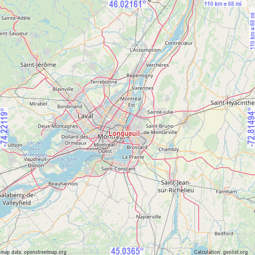
Longueuil GPS coordinates[2]
45° 31' 52.356" North, 73° 31' 5.016" West
| Map corner | latitude | longitude |
|---|---|---|
| Upper-left | 46.02161°, | -74.22119° |
| Center: | 45.53121°, | -73.51806° |
| Lower-right: | 45.0365°, | -72.81494° |
| Map W x H: | 109.5×109.5 km | = 68×68mi |
| max Lat: | 73.03752° ⇑74.1% North |
| Longueuil: | 45.53121° |
| min Lat: | ⇓25.9% South 42.05009° |
| min Long | Longueuil | max Long |
| -139.43328° | -73.51806° | -52.70931° |
| W 67.8%⇐ | ⇒32.2% E |
Elevation
Elevation of Longueuil is 18 m = 59 ft, and this is 236.4 m = 776 ft below average elevation for this country.
| Max E: |
1518 m = 4980 ft | 86.8% |
| Avg. | 254.4 m = 835 ft | |
| Longueuil | 18 m = 59 ft | |
Min E: |
-2 m = -7 ft | 13.2% |
See also: Longueuil elevation on elevation.city.
Geographical zone
Longueuil is located in North temperate zone (between Tropic of Cancer and the Arctic Circle). Distance of this North polar circle is 2338.6 km =1453.1 mi to North.| Distance of | km | miles | from Longueuil |
|---|---|---|---|
| North Pole | 4944.5 | 3072.4 | to North |
| Arctic Circle | 2338.6 | 1453.1 | to North |
| Tropic Cancer | 2456.7 | 1526.5 | to South |
| Equator | 5062.6 | 3145.8 | to South |


Nearby cities:
15 places around Longueuil: (largest is in red/bold)
• Boucherville
9.2 km =5.7 mi,  43°
43°
• Brossard
9.9 km =6.2 mi,  155°
155°
• Hampstead
12.6 km =7.8 mi,  243°
243°
• La Prairie
12.8 km =8 mi,  173°
173°
• Mont-Royal
10.3 km =6.4 mi,  261°
261°
• Montréal
6 km =3.7 mi,  245°
245°
• Montréal-Est
11.2 km =7 mi,  4°
4°
• Notre-Dame-de-Grâce
9.6 km =6 mi,  231°
231°
• Saint-Bruno-de-Montarville
13.2 km =8.2 mi,  88°
88°
• Saint-Laurent
12 km =7.5 mi, 253°
• Saint-Léonard
8.7 km =5.4 mi,  316°
316°
• Saint-Michel
9 km =5.6 mi,  296°
296°
• Saint-Raymond
10.1 km =6.3 mi,  224°
224°
• Saint-Victor
8.9 km =5.5 mi, 1°
• Westmount
8.3 km =5.2 mi, 229°
Sources, notices
• [Note1] Compared only with cities in Canada existing in our database
• [Src1] Map data: © OpenStreetMap contributors (CC-BY-SA)
• [Src2] Other city data from geonames.org with taken over terms of usage.
• [Src3] Geographical zone / Annual Mean Temperature by Robert A. Rohde @ Wikipedia
