Granby geodata
Granby (Quebec) is a populated place; located in Canada in America/Toronto (GMT-4) time zone. With population of 53,979 people, there are 97 cities with bigger population in this country. Compared to other cities in Canada, 78.5% of cities are located further ↑North; 73.7% of cities are located further ←West and 59.5% of cities have higher elevation than Granby. Note1


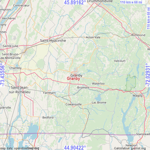
Granby GPS coordinates[2]
45° 24' 0.288" North, 72° 43' 56.748" West
| Map corner | latitude | longitude |
|---|---|---|
| Upper-left | 45.89162°, | -73.43556° |
| Center: | 45.40008°, | -72.73243° |
| Lower-right: | 44.90422°, | -72.02931° |
| Map W x H: | 109.8×109.8 km | = 68.2×68.2mi |
| max Lat: | 73.03752° ⇑78.5% North |
| Granby: | 45.40008° |
| min Lat: | ⇓21.5% South 42.05009° |
| min Long | Granby | max Long |
| -139.43328° | -72.73243° | -52.70931° |
| W 73.7%⇐ | ⇒26.3% E |
Elevation
Elevation of Granby is 102 m = 335 ft, and this is 152.4 m = 500 ft below average elevation for this country.
| Max E: |
1518 m = 4980 ft | 59.5% |
| Avg. | 254.4 m = 835 ft | |
| Granby | 102 m = 335 ft | |
Min E: |
-2 m = -7 ft | 40.5% |
See also: Granby elevation on elevation.city.
Geographical zone
Granby is located in North temperate zone (between Tropic of Cancer and the Arctic Circle). Distance of this North polar circle is 2353.2 km =1462.2 mi to North.| Distance of | km | miles | from Granby |
|---|---|---|---|
| North Pole | 4959 | 3081.4 | to North |
| Arctic Circle | 2353.2 | 1462.2 | to North |
| Tropic Cancer | 2442.1 | 1517.5 | to South |
| Equator | 5048 | 3136.7 | to South |


Nearby cities:
15 places around Granby: (largest is in red/bold)
• Acton Vale
30.7 km =19.1 mi,  25°
25°
• Ange-Gardien
16.6 km =10.3 mi,  250°
250°
• Bromont
11.3 km =7 mi,  144°
144°
• Cowansville
22.3 km =13.9 mi,  183°
183°
• Dunham
30.1 km =18.7 mi,  189°
189°
• Farnham
23.5 km =14.6 mi,  236°
236°
• Lac-Brome
26.5 km =16.5 mi, 140°
• Rougemont
25 km =15.5 mi,  278°
278°
• Saint-Césaire
20.9 km =13 mi, 275°
• Saint-Damase
25.5 km =15.8 mi,  305°
305°
• Saint-Hyacinthe
31 km =19.3 mi,  325°
325°
• Saint-Liboire
28 km =17.4 mi,  355°
355°
• Saint-Pie
17.9 km =11.1 mi, 309°
• Sainte-Croix
30.1 km =18.7 mi, 190°
• Waterloo
17.8 km =11.1 mi,  108°
108°
Sources, notices
• [Note1] Compared only with cities in Canada existing in our database
• [Src1] Map data: © OpenStreetMap contributors (CC-BY-SA)
• [Src2] Other city data from geonames.org with taken over terms of usage.
• [Src3] Geographical zone / Annual Mean Temperature by Robert A. Rohde @ Wikipedia
