Hampstead geodata
Hampstead (Quebec) is a populated place; located in Canada in America/Toronto (GMT-4) time zone. With population of 6,996 people, there are 402 cities with bigger population in this country. Compared to other cities in Canada, 75.2% of cities are located further ↑North; 66.1% of cities are located further ←West and 72.4% of cities have higher elevation than Hampstead. Note1


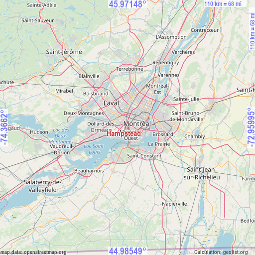
Hampstead GPS coordinates[2]
45° 28' 50.304" North, 73° 39' 47.052" West
| Map corner | latitude | longitude |
|---|---|---|
| Upper-left | 45.97148°, | -74.3662° |
| Center: | 45.48064°, | -73.66307° |
| Lower-right: | 44.98549°, | -72.95995° |
| Map W x H: | 109.6×109.6 km | = 68.1×68.1mi |
| max Lat: | 73.03752° ⇑75.2% North |
| Hampstead: | 45.48064° |
| min Lat: | ⇓24.8% South 42.05009° |
| min Long | Hampstead | max Long |
| -139.43328° | -73.66307° | -52.70931° |
| W 66.1%⇐ | ⇒33.9% E |
Elevation
Elevation of Hampstead is 49 m = 161 ft, and this is 205.4 m = 674 ft below average elevation for this country.
| Max E: |
1518 m = 4980 ft | 72.4% |
| Avg. | 254.4 m = 835 ft | |
| Hampstead | 49 m = 161 ft | |
Min E: |
-2 m = -7 ft | 27.6% |
See also: Canada elevation on elevation.city.
Geographical zone
Hampstead is located in North temperate zone (between Tropic of Cancer and the Arctic Circle). Distance of this North polar circle is 2344.2 km =1456.6 mi to North.| Distance of | km | miles | from Hampstead |
|---|---|---|---|
| North Pole | 4950.1 | 3075.8 | to North |
| Arctic Circle | 2344.2 | 1456.6 | to North |
| Tropic Cancer | 2451.1 | 1523 | to South |
| Equator | 5057 | 3142.3 | to South |


Nearby cities:
15 places around Hampstead: (largest is in red/bold)
• Châteauguay
12.7 km =7.9 mi,  211°
211°
• Côte-Saint-Luc
1.7 km =1.1 mi,  187°
187°
• Dorval
8 km =5 mi,  242°
242°
• Laval
10.2 km =6.3 mi,  347°
347°
• Longueuil
12.6 km =7.8 mi,  63°
63°
• Mont-Royal
4.2 km =2.6 mi,  15°
15°
• Montréal
6.7 km =4.2 mi, 61°
• Montréal-Ouest
3.3 km =2.1 mi,  160°
160°
• Notre-Dame-de-Grâce
3.8 km =2.4 mi,  96°
96°
• Pointe-Claire
12.5 km =7.8 mi,  253°
253°
• Saint-Laurent
2.2 km =1.4 mi, 354°
• Saint-Michel
10.2 km =6.3 mi, 18°
• Saint-Raymond
4.4 km =2.7 mi,  109°
109°
• Sainte-Catherine
10.9 km =6.8 mi,  144°
144°
• Westmount
5 km =3.1 mi,  86°
86°
Sources, notices
• [Note1] Compared only with cities in Canada existing in our database
• [Src1] Map data: © OpenStreetMap contributors (CC-BY-SA)
• [Src2] Other city data from geonames.org with taken over terms of usage.
• [Src3] Geographical zone / Annual Mean Temperature by Robert A. Rohde @ Wikipedia
