Notre-Dame-de-Grâce geodata
Notre-Dame-de-Grâce (Quebec) is a section of populated place; located in Canada in America/Toronto (GMT-4) time zone. With population of 67,000 people, there are 83 cities with bigger population in this country. Compared to other cities in Canada, 75.4% of cities are located further ↑North; 66.7% of cities are located further ←West and 63.6% of cities have higher elevation than Notre-Dame-de-Grâce. Note1
Administrative division(s):
- Level 1: Quebec
- Level 2: Montréal
- Level 3: Montréal
- Level 4: Côte-des-Neiges-Notre-Dame-de-Grâce


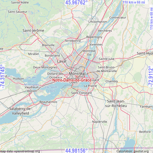
Notre-Dame-de-Grâce GPS coordinates[2]
45° 28' 36.3" North, 73° 36' 51.552" West
| Map corner | latitude | longitude |
|---|---|---|
| Upper-left | 45.96762°, | -74.31745° |
| Center: | 45.47675°, | -73.61432° |
| Lower-right: | 44.98156°, | -72.9112° |
| Map W x H: | 109.6×109.6 km | = 68.1×68.1mi |
| max Lat: | 73.03752° ⇑75.4% North |
| Notre-Dame-de-Grâce: | 45.47675° |
| min Lat: | ⇓24.6% South 42.05009° |
| min Long | Notre-Dame-de-G | max Long |
| -139.43328° | -73.61432° | -52.70931° |
| W 66.7%⇐ | ⇒33.3% E |
Elevation
Elevation of Notre-Dame-de-Grâce is 84 m = 276 ft, and this is 170.4 m = 559 ft below average elevation for this country.
| Max E: |
1518 m = 4980 ft | 63.6% |
| Avg. | 254.4 m = 835 ft | |
| Notre-Dame-de-Grâce | 84 m = 276 ft | |
Min E: |
-2 m = -7 ft | 36.4% |
See also: Notre-Dame-de-Grâce elevation on elevation.city.
Geographical zone
Notre-Dame-de-Grâce is located in North temperate zone (between Tropic of Cancer and the Arctic Circle). Distance of this North polar circle is 2344.6 km =1456.9 mi to North.| Distance of | km | miles | from Notre-Dame-de-Grâce |
|---|---|---|---|
| North Pole | 4950.5 | 3076.1 | to North |
| Arctic Circle | 2344.6 | 1456.9 | to North |
| Tropic Cancer | 2450.6 | 1522.7 | to South |
| Equator | 5056.5 | 3142 | to South |


Nearby cities:
15 places around Notre-Dame-de-Grâce: (largest is in red/bold)
• Brossard
12 km =7.5 mi,  104°
104°
• Côte-Saint-Luc
4.2 km =2.6 mi,  252°
252°
• Dorval
11.3 km =7 mi, 253°
• Hampstead
3.8 km =2.4 mi,  276°
276°
• La Prairie
11.2 km =7 mi,  126°
126°
• Laval
12 km =7.5 mi,  329°
329°
• Longueuil
9.6 km =6 mi,  51°
51°
• Mont-Royal
5.2 km =3.2 mi, 328°
• Montréal
4.1 km =2.5 mi,  30°
30°
• Montréal-Ouest
3.8 km =2.4 mi,  225°
225°
• Saint-Laurent
4.8 km =3 mi,  302°
302°
• Saint-Michel
10.1 km =6.3 mi,  356°
356°
• Saint-Raymond
1.2 km =0.7 mi,  160°
160°
• Sainte-Catherine
8.9 km =5.5 mi, 163°
• Westmount
1.4 km =0.9 mi,  57°
57°
Sources, notices
• [Note1] Compared only with cities in Canada existing in our database
• [Src1] Map data: © OpenStreetMap contributors (CC-BY-SA)
• [Src2] Other city data from geonames.org with taken over terms of usage.
• [Src3] Geographical zone / Annual Mean Temperature by Robert A. Rohde @ Wikipedia
