Laval geodata
Laval (Quebec) is a populated place; located in Canada in America/Toronto (GMT-4) time zone. With population of 376,845 people, there are 14 cities with bigger population in this country. Compared to other cities in Canada, 72.7% of cities are located further ↑North; 65.8% of cities are located further ←West and 78.7% of cities have higher elevation than Laval. Note1


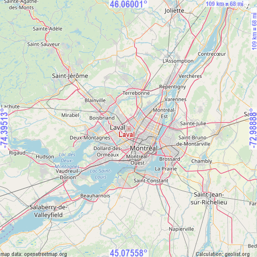
Laval GPS coordinates[2]
45° 34' 11.82" North, 73° 41' 31.2" West
| Map corner | latitude | longitude |
|---|---|---|
| Upper-left | 46.06001°, | -74.39513° |
| Center: | 45.56995°, | -73.692° |
| Lower-right: | 45.07558°, | -72.98888° |
| Map W x H: | 109.5×109.5 km | = 68×68mi |
| max Lat: | 73.03752° ⇑72.7% North |
| Laval: | 45.56995° |
| min Lat: | ⇓27.3% South 42.05009° |
| min Long | Laval | max Long |
| -139.43328° | -73.692° | -52.70931° |
| W 65.8%⇐ | ⇒34.2% E |
Elevation
Elevation of Laval is 34 m = 112 ft, and this is 220.4 m = 723 ft below average elevation for this country.
| Max E: |
1518 m = 4980 ft | 78.7% |
| Avg. | 254.4 m = 835 ft | |
| Laval | 34 m = 112 ft | |
Min E: |
-2 m = -7 ft | 21.3% |
See also: Laval elevation on elevation.city.
Geographical zone
Laval is located in North temperate zone (between Tropic of Cancer and the Arctic Circle). Distance of this North polar circle is 2334.3 km =1450.5 mi to North.| Distance of | km | miles | from Laval |
|---|---|---|---|
| North Pole | 4940.2 | 3069.7 | to North |
| Arctic Circle | 2334.3 | 1450.5 | to North |
| Tropic Cancer | 2461 | 1529.2 | to South |
| Equator | 5066.9 | 3148.4 | to South |


Nearby cities:
15 places around Laval: (largest is in red/bold)
• Bois-des-Filion
11.6 km =7.2 mi,  337°
337°
• Boisbriand
12.1 km =7.5 mi,  295°
295°
• Côte-Saint-Luc
11.8 km =7.3 mi,  170°
170°
• Hampstead
10.2 km =6.3 mi, 167°
• Mont-Royal
6.8 km =4.2 mi,  150°
150°
• Montréal
10.6 km =6.6 mi,  129°
129°
• Notre-Dame-de-Grâce
12 km =7.5 mi, 149°
• Rosemère
10.9 km =6.8 mi,  310°
310°
• Saint-Elzéar
4.6 km =2.9 mi,  323°
323°
• Saint-Laurent
8 km =5 mi, 165°
• Saint-Léonard
7.8 km =4.8 mi,  75°
75°
• Saint-Michel
5.5 km =3.4 mi,  92°
92°
• Saint-Raymond
13.1 km =8.1 mi, 150°
• Sainte-Thérèse
13.1 km =8.1 mi, 306°
• Westmount
12 km =7.5 mi,  143°
143°
Sources, notices
• [Note1] Compared only with cities in Canada existing in our database
• [Src1] Map data: © OpenStreetMap contributors (CC-BY-SA)
• [Src2] Other city data from geonames.org with taken over terms of usage.
• [Src3] Geographical zone / Annual Mean Temperature by Robert A. Rohde @ Wikipedia
