Saint-Laurent geodata
Saint-Laurent (Quebec) is a section of populated place; located in Canada in America/Toronto (GMT-4) time zone. With population of 77,391 people, there are 68 cities with bigger population in this country. Compared to other cities in Canada, 74.8% of cities are located further ↑North; 65.9% of cities are located further ←West and 75.8% of cities have higher elevation than Saint-Laurent. Note1


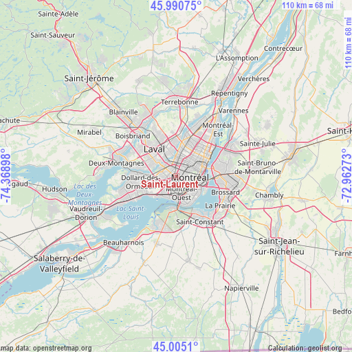
Saint-Laurent GPS coordinates[2]
45° 30' 0.288" North, 73° 39' 57.06" West
| Map corner | latitude | longitude |
|---|---|---|
| Upper-left | 45.99075°, | -74.36898° |
| Center: | 45.50008°, | -73.66585° |
| Lower-right: | 45.0051°, | -72.96273° |
| Map W x H: | 109.6×109.6 km | = 68.1×68.1mi |
| max Lat: | 73.03752° ⇑74.8% North |
| Saint-Laurent: | 45.50008° |
| min Lat: | ⇓25.2% South 42.05009° |
| min Long | Saint-Laurent | max Long |
| -139.43328° | -73.66585° | -52.70931° |
| W 65.9%⇐ | ⇒34.1% E |
Elevation
Elevation of Saint-Laurent is 41 m = 135 ft, and this is 213.4 m = 700 ft below average elevation for this country.
| Max E: |
1518 m = 4980 ft | 75.8% |
| Avg. | 254.4 m = 835 ft | |
| Saint-Laurent | 41 m = 135 ft | |
Min E: |
-2 m = -7 ft | 24.2% |
See also: Saint-Laurent elevation on elevation.city.
Geographical zone
Saint-Laurent is located in North temperate zone (between Tropic of Cancer and the Arctic Circle). Distance of this North polar circle is 2342 km =1455.3 mi to North.| Distance of | km | miles | from Saint-Laurent |
|---|---|---|---|
| North Pole | 4947.9 | 3074.5 | to North |
| Arctic Circle | 2342 | 1455.3 | to North |
| Tropic Cancer | 2453.2 | 1524.3 | to South |
| Equator | 5059.1 | 3143.6 | to South |


Nearby cities:
15 places around Saint-Laurent: (largest is in red/bold)
• Côte-Saint-Luc
3.9 km =2.4 mi,  180°
180°
• Dollard-Des Ormeaux
12.4 km =7.7 mi,  267°
267°
• Dorval
9 km =5.6 mi,  229°
229°
• Hampstead
2.2 km =1.4 mi,  174°
174°
• Laval
8 km =5 mi,  345°
345°
• Longueuil
12 km =7.5 mi,  73°
73°
• Mont-Royal
2.3 km =1.4 mi,  35°
35°
• Montréal
6.2 km =3.9 mi,  80°
80°
• Montréal-Ouest
5.4 km =3.4 mi, 166°
• Notre-Dame-de-Grâce
4.8 km =3 mi,  122°
122°
• Saint-Elzéar
12.4 km =7.7 mi,  337°
337°
• Saint-Léonard
11.2 km =7 mi,  29°
29°
• Saint-Michel
8.3 km =5.2 mi,  24°
24°
• Saint-Raymond
5.7 km =3.5 mi,  129°
129°
• Westmount
5.5 km =3.4 mi,  109°
109°
Sources, notices
• [Note1] Compared only with cities in Canada existing in our database
• [Src1] Map data: © OpenStreetMap contributors (CC-BY-SA)
• [Src2] Other city data from geonames.org with taken over terms of usage.
• [Src3] Geographical zone / Annual Mean Temperature by Robert A. Rohde @ Wikipedia
