Headingley geodata
Headingley (Manitoba) is a populated place; located in Canada in America/Winnipeg (GMT-5) time zone. With population of 3,215 people, there are 591 cities with bigger population in this country. Compared to other cities in Canada, 74.6% of cities are located further ↓South; 67% of cities are located further →East and 61.2% of cities have lower elevation than Headingley. Note1


Headingley GPS coordinates[2]
49° 52' 31.08" North, 97° 24' 32.256" West
| Map corner | latitude | longitude |
|---|---|---|
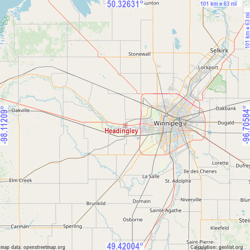
| Upper-left | 50.32631°, | -98.11209° |
| Center: | 49.8753°, | -97.40896° |
| Lower-right: | 49.42004°, | -96.70584° |
| Map W x H: | 100.8×100.8 km | = 62.6×62.6mi |
| max Lat: | 73.03752° ⇑25.4% North |
| Headingley: | 49.8753° |
| min Lat: | ⇓74.6% South 42.05009° |
| min Long | Headingley | max Long |
| -139.43328° | -97.40896° | -52.70931° |
| W 33%⇐ | ⇒67% E |
Elevation
Elevation of Headingley is 239 m = 784 ft, and this is 15.4 m = 51 ft below average elevation for this country.
| Max E: |
1518 m = 4980 ft | 38.8% |
| Avg. | 254.4 m = 835 ft | |
| Headingley | 239 m = 784 ft | |
Min E: |
-2 m = -7 ft | 61.2% |
See also: Canada elevation on elevation.city.
Geographical zone
Headingley is located in North temperate zone (between Tropic of Cancer and the Arctic Circle). Distance of this North polar circle is 1855.6 km =1153 mi to North.| Distance of | km | miles | from Headingley |
|---|---|---|---|
| North Pole | 4461.4 | 2772.2 | to North |
| Arctic Circle | 1855.6 | 1153 | to North |
| Tropic Cancer | 2939.7 | 1826.6 | to South |
| Equator | 5545.6 | 3445.9 | to South |


Nearby cities:
15 places around Headingley: (largest is in red/bold)
• Carman
59.7 km =37.1 mi,  225°
225°
• Garson
55 km =34.2 mi,  65°
65°
• Ile des Chênes
35.3 km =21.9 mi,  121°
121°
• Landmark
47.8 km =29.7 mi, 118°
• Lorette
41.4 km =25.7 mi,  111°
111°
• Morris
57.9 km =36 mi,  176°
176°
• Niverville
39.9 km =24.8 mi,  138°
138°
• Portage la Prairie
64.2 km =39.9 mi,  279°
279°
• Selkirk
47.9 km =29.8 mi,  51°
51°
• St. Adolphe
30.9 km =19.2 mi, 136°
• St. François Xavier
10.4 km =6.5 mi,  293°
293°
• Stonewall
29.4 km =18.3 mi,  11°
11°
• Tyndall
58.4 km =36.3 mi, 66°
• Warren
30.2 km =18.8 mi,  340°
340°
• Winnipeg
18.8 km =11.7 mi,  86°
86°
Sources, notices
• [Note1] Compared only with cities in Canada existing in our database
• [Src1] Map data: © OpenStreetMap contributors (CC-BY-SA)
• [Src2] Other city data from geonames.org with taken over terms of usage.
• [Src3] Geographical zone / Annual Mean Temperature by Robert A. Rohde @ Wikipedia
