Tyndall geodata
Tyndall (Manitoba) is a populated place; located in Canada in America/Winnipeg (GMT-5) time zone. With population of 935 people, there are 1071 cities with bigger population in this country. Compared to other cities in Canada, 76.6% of cities are located further ↓South; 65.7% of cities are located further →East and 62.5% of cities have lower elevation than Tyndall. Note1


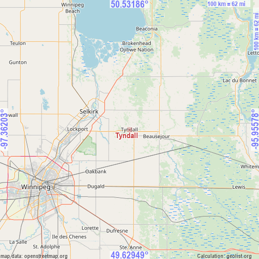
Tyndall GPS coordinates[2]
50° 4' 58.08" North, 96° 39' 32.04" West
| Map corner | latitude | longitude |
|---|---|---|
| Upper-left | 50.53186°, | -97.36203° |
| Center: | 50.0828°, | -96.6589° |
| Lower-right: | 49.62949°, | -95.95578° |
| Map W x H: | 100.3×100.3 km | = 62.3×62.3mi |
| max Lat: | 73.03752° ⇑23.4% North |
| Tyndall: | 50.0828° |
| min Lat: | ⇓76.6% South 42.05009° |
| min Long | Tyndall | max Long |
| -139.43328° | -96.6589° | -52.70931° |
| W 34.3%⇐ | ⇒65.7% E |
Elevation
Elevation of Tyndall is 242 m = 794 ft, and this is 12.4 m = 41 ft below average elevation for this country.
| Max E: |
1518 m = 4980 ft | 37.5% |
| Avg. | 254.4 m = 835 ft | |
| Tyndall | 242 m = 794 ft | |
Min E: |
-2 m = -7 ft | 62.5% |
See also: Canada elevation on elevation.city.
Geographical zone
Tyndall is located in North temperate zone (between Tropic of Cancer and the Arctic Circle). Distance of this North polar circle is 1832.5 km =1138.7 mi to North.| Distance of | km | miles | from Tyndall |
|---|---|---|---|
| North Pole | 4438.4 | 2757.9 | to North |
| Arctic Circle | 1832.5 | 1138.7 | to North |
| Tropic Cancer | 2962.8 | 1841 | to South |
| Equator | 5568.7 | 3460.2 | to South |


Nearby cities:
15 places around Tyndall: (largest is in red/bold)
• Beausejour
10.4 km =6.5 mi,  102°
102°
• Garson
3.5 km =2.2 mi,  260°
260°
• Headingley
58.4 km =36.3 mi,  246°
246°
• Ile des Chênes
47.7 km =29.6 mi,  209°
209°
• Lac du Bonnet
46.6 km =29 mi,  65°
65°
• Landmark
47.2 km =29.3 mi,  194°
194°
• Lorette
41.1 km =25.5 mi,  201°
201°
• Niverville
59.8 km =37.2 mi, 207°
• Pine Falls
62.2 km =38.6 mi,  30°
30°
• Powerview
62.9 km =39.1 mi, 31°
• Selkirk
17.5 km =10.9 mi,  292°
292°
• St. Adolphe
55.8 km =34.7 mi,  215°
215°
• Steinbach
62 km =38.5 mi,  181°
181°
• Stonewall
48 km =29.8 mi,  276°
276°
• Winnipeg
41.3 km =25.7 mi,  237°
237°
Sources, notices
• [Note1] Compared only with cities in Canada existing in our database
• [Src1] Map data: © OpenStreetMap contributors (CC-BY-SA)
• [Src2] Other city data from geonames.org with taken over terms of usage.
• [Src3] Geographical zone / Annual Mean Temperature by Robert A. Rohde @ Wikipedia
