Niverville geodata
Niverville (Manitoba) is a populated place; located in Canada in America/Winnipeg (GMT-5) time zone. With population of 2,000 people, there are 750 cities with bigger population in this country. Compared to other cities in Canada, 71.1% of cities are located further ↓South; 66.5% of cities are located further →East and 60.4% of cities have lower elevation than Niverville. Note1


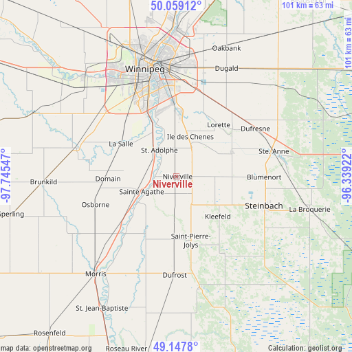
Niverville GPS coordinates[2]
49° 36' 20.124" North, 97° 2' 32.424" West
| Map corner | latitude | longitude |
|---|---|---|
| Upper-left | 50.05912°, | -97.74547° |
| Center: | 49.60559°, | -97.04234° |
| Lower-right: | 49.1478°, | -96.33922° |
| Map W x H: | 101.3×101.3 km | = 62.9×62.9mi |
| max Lat: | 73.03752° ⇑28.9% North |
| Niverville: | 49.60559° |
| min Lat: | ⇓71.1% South 42.05009° |
| min Long | Niverville | max Long |
| -139.43328° | -97.04234° | -52.70931° |
| W 33.5%⇐ | ⇒66.5% E |
Elevation
Elevation of Niverville is 235 m = 771 ft, and this is 19.4 m = 64 ft below average elevation for this country.
| Max E: |
1518 m = 4980 ft | 39.6% |
| Avg. | 254.4 m = 835 ft | |
| Niverville | 235 m = 771 ft | |
Min E: |
-2 m = -7 ft | 60.4% |
See also: Canada elevation on elevation.city.
Geographical zone
Niverville is located in North temperate zone (between Tropic of Cancer and the Arctic Circle). Distance of this North polar circle is 1885.5 km =1171.6 mi to North.| Distance of | km | miles | from Niverville |
|---|---|---|---|
| North Pole | 4491.4 | 2790.8 | to North |
| Arctic Circle | 1885.5 | 1171.6 | to North |
| Tropic Cancer | 2909.7 | 1808 | to South |
| Equator | 5515.6 | 3427.2 | to South |


Nearby cities:
15 places around Niverville: (largest is in red/bold)
• Garson
57.7 km =35.9 mi,  24°
24°
• Grunthal
25.8 km =16 mi,  149°
149°
• Headingley
39.9 km =24.8 mi,  318°
318°
• Ile des Chênes
12.3 km =7.6 mi, 18°
• La Broquerie
40.3 km =25 mi,  104°
104°
• Landmark
17.5 km =10.9 mi,  65°
65°
• Lorette
19.2 km =11.9 mi,  39°
39°
• Morris
36.4 km =22.6 mi,  219°
219°
• Selkirk
60.9 km =37.8 mi,  10°
10°
• St. Adolphe
9.1 km =5.7 mi,  327°
327°
• St. François Xavier
49.6 km =30.8 mi,  313°
313°
• St. Jean Baptiste
43.5 km =27 mi,  209°
209°
• Steinbach
27.3 km =17 mi,  108°
108°
• Tyndall
59.8 km =37.2 mi,  27°
27°
• Winnipeg
31.9 km =19.8 mi,  346°
346°
Sources, notices
• [Note1] Compared only with cities in Canada existing in our database
• [Src1] Map data: © OpenStreetMap contributors (CC-BY-SA)
• [Src2] Other city data from geonames.org with taken over terms of usage.
• [Src3] Geographical zone / Annual Mean Temperature by Robert A. Rohde @ Wikipedia
