Winnipeg geodata
Winnipeg (Manitoba) is a seat of a first-order administrative division; located in Canada in America/Winnipeg (GMT-5) time zone. With population of 632,063 people, there are 7 cities with bigger population in this country. Compared to other cities in Canada, 74.9% of cities are located further ↓South; 66.7% of cities are located further →East and 62.7% of cities have lower elevation than Winnipeg. Note1


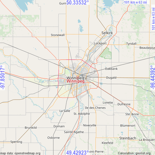
Winnipeg GPS coordinates[2]
49° 53' 3.84" North, 97° 8' 49.344" West
| Map corner | latitude | longitude |
|---|---|---|
| Upper-left | 50.33532°, | -97.85017° |
| Center: | 49.8844°, | -97.14704° |
| Lower-right: | 49.42923°, | -96.44392° |
| Map W x H: | 100.7×100.7 km | = 62.6×62.6mi |
| max Lat: | 73.03752° ⇑25.1% North |
| Winnipeg: | 49.8844° |
| min Lat: | ⇓74.9% South 42.05009° |
| min Long | Winnipeg | max Long |
| -139.43328° | -97.14704° | -52.70931° |
| W 33.3%⇐ | ⇒66.7% E |
Elevation
Elevation of Winnipeg is 245 m = 804 ft, and this is 9.4 m = 31 ft below average elevation for this country.
| Max E: |
1518 m = 4980 ft | 37.3% |
| Avg. | 254.4 m = 835 ft | |
| Winnipeg | 245 m = 804 ft | |
Min E: |
-2 m = -7 ft | 62.7% |
See also: Winnipeg elevation on elevation.city.
Geographical zone
Winnipeg is located in North temperate zone (between Tropic of Cancer and the Arctic Circle). Distance of this North polar circle is 1854.5 km =1152.3 mi to North.| Distance of | km | miles | from Winnipeg |
|---|---|---|---|
| North Pole | 4460.4 | 2771.6 | to North |
| Arctic Circle | 1854.5 | 1152.3 | to North |
| Tropic Cancer | 2940.7 | 1827.3 | to South |
| Equator | 5546.6 | 3446.5 | to South |


Nearby cities:
15 places around Winnipeg: (largest is in red/bold)
• Beausejour
49.2 km =30.6 mi,  66°
66°
• Garson
38.1 km =23.7 mi,  55°
55°
• Grunthal
57 km =35.4 mi,  158°
158°
• Headingley
18.8 km =11.7 mi,  266°
266°
• Ile des Chênes
22.4 km =13.9 mi,  149°
149°
• Landmark
33.2 km =20.6 mi,  135°
135°
• Lorette
25.5 km =15.8 mi,  129°
129°
• Niverville
31.9 km =19.8 mi,  166°
166°
• Selkirk
34.4 km =21.4 mi,  33°
33°
• St. Adolphe
23.5 km =14.6 mi, 173°
• St. François Xavier
28.5 km =17.7 mi,  276°
276°
• Steinbach
51.9 km =32.2 mi, 140°
• Stonewall
30.6 km =19 mi,  335°
335°
• Tyndall
41.3 km =25.7 mi, 57°
• Warren
39.7 km =24.7 mi,  313°
313°
Sources, notices
• [Note1] Compared only with cities in Canada existing in our database
• [Src1] Map data: © OpenStreetMap contributors (CC-BY-SA)
• [Src2] Other city data from geonames.org with taken over terms of usage.
• [Src3] Geographical zone / Annual Mean Temperature by Robert A. Rohde @ Wikipedia
