St. Adolphe geodata
St. Adolphe (Manitoba) is a populated place; located in Canada in America/Winnipeg (GMT-5) time zone. With population of 1,362 people, there are 898 cities with bigger population in this country. Compared to other cities in Canada, 72.2% of cities are located further ↓South; 66.6% of cities are located further →East and 60.3% of cities have lower elevation than St. Adolphe. Note1


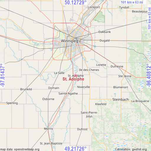
St. Adolphe GPS coordinates[2]
49° 40' 27.84" North, 97° 6' 40.464" West
| Map corner | latitude | longitude |
|---|---|---|
| Upper-left | 50.12729°, | -97.81437° |
| Center: | 49.6744°, | -97.11124° |
| Lower-right: | 49.21726°, | -96.40812° |
| Map W x H: | 101.2×101.2 km | = 62.9×62.9mi |
| max Lat: | 73.03752° ⇑27.8% North |
| St. Adolphe: | 49.6744° |
| min Lat: | ⇓72.2% South 42.05009° |
| min Long | St. Adolphe | max Long |
| -139.43328° | -97.11124° | -52.70931° |
| W 33.4%⇐ | ⇒66.6% E |
Elevation
Elevation of St. Adolphe is 234 m = 768 ft, and this is 20.4 m = 67 ft below average elevation for this country.
| Max E: |
1518 m = 4980 ft | 39.7% |
| Avg. | 254.4 m = 835 ft | |
| St. Adolphe | 234 m = 768 ft | |
Min E: |
-2 m = -7 ft | 60.3% |
See also: Canada elevation on elevation.city.
Geographical zone
St. Adolphe is located in North temperate zone (between Tropic of Cancer and the Arctic Circle). Distance of this North polar circle is 1877.9 km =1166.9 mi to North.| Distance of | km | miles | from St. Adolphe |
|---|---|---|---|
| North Pole | 4483.8 | 2786.1 | to North |
| Arctic Circle | 1877.9 | 1166.9 | to North |
| Tropic Cancer | 2917.4 | 1812.8 | to South |
| Equator | 5523.3 | 3432 | to South |


Nearby cities:
15 places around St. Adolphe: (largest is in red/bold)
• Garson
53.4 km =33.2 mi,  32°
32°
• Grunthal
34.9 km =21.7 mi,  148°
148°
• Headingley
30.9 km =19.2 mi,  316°
316°
• Ile des Chênes
9.7 km =6 mi,  65°
65°
• La Broquerie
47.4 km =29.5 mi,  111°
111°
• Landmark
20.8 km =12.9 mi,  90°
90°
• Lorette
18.6 km =11.6 mi, 67°
• Morris
40 km =24.9 mi,  207°
207°
• Niverville
9.1 km =5.7 mi, 147°
• Selkirk
54.6 km =33.9 mi,  17°
17°
• St. François Xavier
40.7 km =25.3 mi,  310°
310°
• St. Jean Baptiste
48.4 km =30.1 mi,  200°
200°
• Steinbach
34.9 km =21.7 mi,  118°
118°
• Stonewall
53.4 km =33.2 mi,  343°
343°
• Winnipeg
23.5 km =14.6 mi,  353°
353°
Sources, notices
• [Note1] Compared only with cities in Canada existing in our database
• [Src1] Map data: © OpenStreetMap contributors (CC-BY-SA)
• [Src2] Other city data from geonames.org with taken over terms of usage.
• [Src3] Geographical zone / Annual Mean Temperature by Robert A. Rohde @ Wikipedia
