Morris geodata
Morris (Manitoba) is a populated place; located in Canada in America/Winnipeg (GMT-5) time zone. With population of 1,742 people, there are 803 cities with bigger population in this country. Compared to other cities in Canada, 68.7% of cities are located further ↓South; 66.9% of cities are located further →East and 60.8% of cities have lower elevation than Morris. Note1


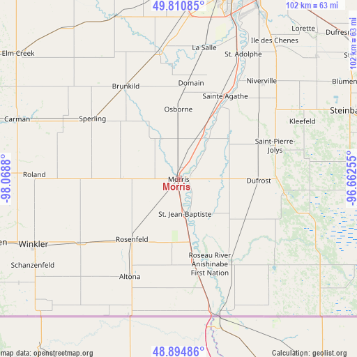
Morris GPS coordinates[2]
49° 21' 17.964" North, 97° 21' 56.412" West
| Map corner | latitude | longitude |
|---|---|---|
| Upper-left | 49.81085°, | -98.0688° |
| Center: | 49.35499°, | -97.36567° |
| Lower-right: | 48.89486°, | -96.66255° |
| Map W x H: | 101.8×101.8 km | = 63.3×63.3mi |
| max Lat: | 73.03752° ⇑31.3% North |
| Morris: | 49.35499° |
| min Lat: | ⇓68.7% South 42.05009° |
| min Long | Morris | max Long |
| -139.43328° | -97.36567° | -52.70931° |
| W 33.1%⇐ | ⇒66.9% E |
Elevation
Elevation of Morris is 236 m = 774 ft, and this is 18.4 m = 60 ft below average elevation for this country.
| Max E: |
1518 m = 4980 ft | 39.2% |
| Avg. | 254.4 m = 835 ft | |
| Morris | 236 m = 774 ft | |
Min E: |
-2 m = -7 ft | 60.8% |
See also: Canada elevation on elevation.city.
Geographical zone
Morris is located in North temperate zone (between Tropic of Cancer and the Arctic Circle). Distance of this North polar circle is 1913.4 km =1188.9 mi to North.| Distance of | km | miles | from Morris |
|---|---|---|---|
| North Pole | 4519.3 | 2808.2 | to North |
| Arctic Circle | 1913.4 | 1188.9 | to North |
| Tropic Cancer | 2881.8 | 1790.7 | to South |
| Equator | 5487.8 | 3410 | to South |


Nearby cities:
15 places around Morris: (largest is in red/bold)
• Altona
31.2 km =19.4 mi,  206°
206°
• Carman
48.7 km =30.3 mi,  289°
289°
• Grunthal
37.1 km =23.1 mi,  81°
81°
• Headingley
57.9 km =36 mi,  356°
356°
• Ile des Chênes
48 km =29.8 mi,  34°
34°
• Landmark
52.7 km =32.7 mi,  48°
48°
• Lorette
55.6 km =34.5 mi,  39°
39°
• Morden
56.4 km =35 mi,  251°
251°
• Niverville
36.4 km =22.6 mi, 39°
• St. Adolphe
40 km =24.9 mi, 27°
• St. François Xavier
63.3 km =39.3 mi,  348°
348°
• St. Jean Baptiste
10.1 km =6.3 mi,  169°
169°
• Steinbach
52.8 km =32.8 mi,  68°
68°
• Winkler
46 km =28.6 mi, 245°
• Winnipeg
60.9 km =37.8 mi,  14°
14°
Sources, notices
• [Note1] Compared only with cities in Canada existing in our database
• [Src1] Map data: © OpenStreetMap contributors (CC-BY-SA)
• [Src2] Other city data from geonames.org with taken over terms of usage.
• [Src3] Geographical zone / Annual Mean Temperature by Robert A. Rohde @ Wikipedia
