Hearst geodata
Hearst (Ontario) is a populated place; located in Canada in America/Toronto (GMT-4) time zone. With population of 4,746 people, there are 485 cities with bigger population in this country. Compared to other cities in Canada, 72.3% of cities are located further ↓South; 63.4% of cities are located further →East and 60.4% of cities have lower elevation than Hearst. Note1


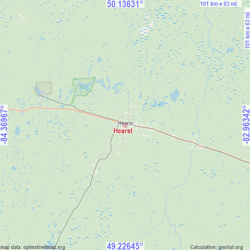
Hearst GPS coordinates[2]
49° 41' 0.636" North, 83° 39' 59.544" West
| Map corner | latitude | longitude |
|---|---|---|
| Upper-left | 50.13631°, | -84.36967° |
| Center: | 49.68351°, | -83.66654° |
| Lower-right: | 49.22645°, | -82.96342° |
| Map W x H: | 101.2×101.2 km | = 62.9×62.9mi |
| max Lat: | 73.03752° ⇑27.7% North |
| Hearst: | 49.68351° |
| min Lat: | ⇓72.3% South 42.05009° |
| min Long | Hearst | max Long |
| -139.43328° | -83.66654° | -52.70931° |
| W 36.6%⇐ | ⇒63.4% E |
Elevation
Elevation of Hearst is 235 m = 771 ft, and this is 19.4 m = 64 ft below average elevation for this country.
| Max E: |
1518 m = 4980 ft | 39.6% |
| Avg. | 254.4 m = 835 ft | |
| Hearst | 235 m = 771 ft | |
Min E: |
-2 m = -7 ft | 60.4% |
See also: Canada elevation on elevation.city.
Geographical zone
Hearst is located in North temperate zone (between Tropic of Cancer and the Arctic Circle). Distance of this North polar circle is 1876.9 km =1166.3 mi to North.| Distance of | km | miles | from Hearst |
|---|---|---|---|
| North Pole | 4482.8 | 2785.5 | to North |
| Arctic Circle | 1876.9 | 1166.3 | to North |
| Tropic Cancer | 2918.4 | 1813.4 | to South |
| Equator | 5524.3 | 3432.6 | to South |


Nearby cities:
15 places around Hearst: (largest is in red/bold)
• Attawapiskat
371 km =230.5 mi,  13°
13°
• Elliot Lake
374.9 km =233 mi,  168°
168°
• Fort Albany
312.9 km =194.4 mi,  26°
26°
• Greenstone
251.7 km =156.4 mi,  271°
271°
• Hornepayne
95.7 km =59.5 mi,  236°
236°
• Iroquois Falls
239.4 km =148.8 mi,  115°
115°
• Kapuskasing
93.8 km =58.3 mi,  108°
108°
• Kirkland Lake
315.5 km =196 mi, 122°
• Manitouwadge
169.2 km =105.1 mi,  248°
248°
• Marathon
226.1 km =140.5 mi, 242°
• Moose Factory
278.5 km =173.1 mi,  50°
50°
• Moosonee
278.4 km =173 mi, 50°
• Sault Ste. Marie
355.6 km =221 mi,  187°
187°
• Timmins
217.2 km =135 mi,  128°
128°
• Wawa
205.1 km =127.4 mi,  203°
203°
Sources, notices
• [Note1] Compared only with cities in Canada existing in our database
• [Src1] Map data: © OpenStreetMap contributors (CC-BY-SA)
• [Src2] Other city data from geonames.org with taken over terms of usage.
• [Src3] Geographical zone / Annual Mean Temperature by Robert A. Rohde @ Wikipedia
