Sault Ste. Marie geodata
Sault Ste. Marie (Ontario) is a seat of a second-order administrative division; located in Canada in America/Toronto (GMT-4) time zone. With population of 66,313 people, there are 85 cities with bigger population in this country. Compared to other cities in Canada, 55.3% of cities are located further ↑North; 63.5% of cities are located further →East and 52.9% of cities have lower elevation than Sault Ste. Marie. Note1


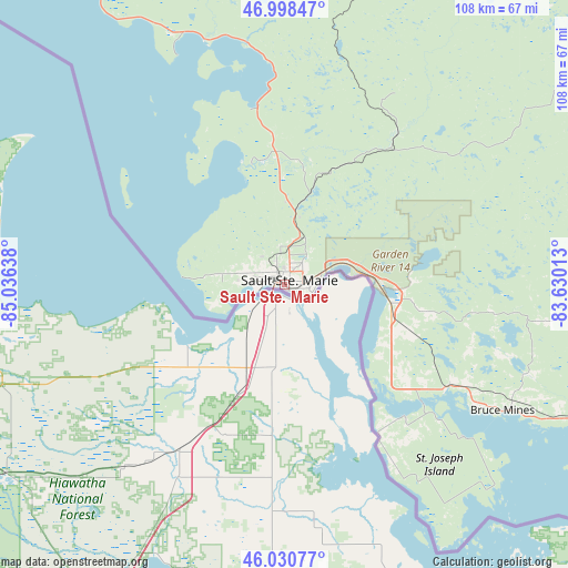
Sault Ste. Marie GPS coordinates[2]
46° 31' 0.372" North, 84° 19' 59.7" West
| Map corner | latitude | longitude |
|---|---|---|
| Upper-left | 46.99847°, | -85.03638° |
| Center: | 46.51677°, | -84.33325° |
| Lower-right: | 46.03077°, | -83.63013° |
| Map W x H: | 107.6×107.6 km | = 66.9×66.9mi |
| max Lat: | 73.03752° ⇑55.3% North |
| Sault Ste. Marie: | 46.51677° |
| min Lat: | ⇓44.7% South 42.05009° |
| min Long | Sault Ste. Mari | max Long |
| -139.43328° | -84.33325° | -52.70931° |
| W 36.5%⇐ | ⇒63.5% E |
Elevation
Elevation of Sault Ste. Marie is 186 m = 610 ft, and this is 68.4 m = 224 ft below average elevation for this country.
| Max E: |
1518 m = 4980 ft | 47.1% |
| Avg. | 254.4 m = 835 ft | |
| Sault Ste. Marie | 186 m = 610 ft | |
Min E: |
-2 m = -7 ft | 52.9% |
See also: Sault Ste. Marie elevation on elevation.city.
Geographical zone
Sault Ste. Marie is located in North temperate zone (between Tropic of Cancer and the Arctic Circle). Distance of this North polar circle is 2229 km =1385 mi to North.| Distance of | km | miles | from Sault Ste. Marie |
|---|---|---|---|
| North Pole | 4834.9 | 3004.3 | to North |
| Arctic Circle | 2229 | 1385 | to North |
| Tropic Cancer | 2566.3 | 1594.6 | to South |
| Equator | 5172.2 | 3213.9 | to South |


Nearby cities:
15 places around Sault Ste. Marie: (largest is in red/bold)
• Azilda
247.3 km =153.7 mi,  89°
89°
• Capreol
261.5 km =162.5 mi, 85°
• Dowling
229.1 km =142.4 mi, 87°
• Elliot Lake
131.1 km =81.5 mi,  96°
96°
• Espanola
198.9 km =123.6 mi, 98°
• Greater Sudbury
255.9 km =159 mi, 90°
• Little Current
194.6 km =120.9 mi,  107°
107°
• Lively
243.9 km =151.6 mi, 92°
• Marathon
293.9 km =182.6 mi,  327°
327°
• Rayside-Balfour
239.2 km =148.6 mi, 87°
• Spanish
156.2 km =97.1 mi, 103°
• Thessalon
65.9 km =40.9 mi,  116°
116°
• Tobermory
249.9 km =155.3 mi, 124°
• Valley East
255.2 km =158.6 mi, 86°
• Wawa
167 km =103.8 mi,  348°
348°
In other languages:
- In France: Sault-Sainte-Marie
- In Italian: Sault Sainte Marie
- In Russian: Су-Сент-Мари
- In Chinese: 蘇聖瑪麗
Sources, notices
• [Note1] Compared only with cities in Canada existing in our database
• [Src1] Map data: © OpenStreetMap contributors (CC-BY-SA)
• [Src2] Other city data from geonames.org with taken over terms of usage.
• [Src3] Geographical zone / Annual Mean Temperature by Robert A. Rohde @ Wikipedia
