Cedar geodata
Cedar (British Columbia) is a populated place; located in Canada in America/Vancouver (GMT-7) time zone. With population of 2,836 people, there are 636 cities with bigger population in this country. Compared to other cities in Canada, 63.7% of cities are located further ↓South; 96% of cities are located further →East and 79.8% of cities have higher elevation than Cedar. Note1


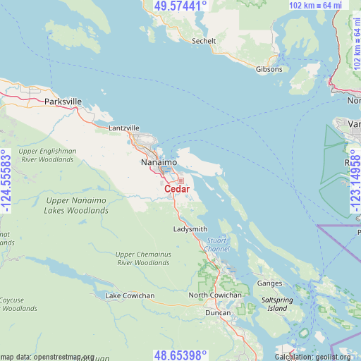
Cedar GPS coordinates[2]
49° 6' 58.788" North, 123° 51' 9.72" West
| Map corner | latitude | longitude |
|---|---|---|
| Upper-left | 49.57441°, | -124.55583° |
| Center: | 49.11633°, | -123.8527° |
| Lower-right: | 48.65398°, | -123.14958° |
| Map W x H: | 102.3×102.3 km | = 63.6×63.6mi |
| max Lat: | 73.03752° ⇑36.3% North |
| Cedar: | 49.11633° |
| min Lat: | ⇓63.7% South 42.05009° |
| min Long | Cedar | max Long |
| -139.43328° | -123.8527° | -52.70931° |
| W 4%⇐ | ⇒96% E |
Elevation
Elevation of Cedar is 32 m = 105 ft, and this is 222.4 m = 730 ft below average elevation for this country.
| Max E: |
1518 m = 4980 ft | 79.8% |
| Avg. | 254.4 m = 835 ft | |
| Cedar | 32 m = 105 ft | |
Min E: |
-2 m = -7 ft | 20.2% |
See also: Canada elevation on elevation.city.
Geographical zone
Cedar is located in North temperate zone (between Tropic of Cancer and the Arctic Circle). Distance of this North polar circle is 1940 km =1205.5 mi to North.| Distance of | km | miles | from Cedar |
|---|---|---|---|
| North Pole | 4545.8 | 2824.6 | to North |
| Arctic Circle | 1940 | 1205.5 | to North |
| Tropic Cancer | 2855.3 | 1774.2 | to South |
| Equator | 5461.2 | 3393.4 | to South |


Nearby cities:
15 places around Cedar: (largest is in red/bold)
• Cassidy
7.8 km =4.8 mi,  198°
198°
• Chemainus
24.3 km =15.1 mi,  156°
156°
• Duncan
38.7 km =24 mi, 163°
• East Wellington
13.6 km =8.5 mi,  298°
298°
• Englishman River South
36.2 km =22.5 mi, 300°
• Fairwinds
26.7 km =16.6 mi,  311°
311°
• Gibsons
40 km =24.9 mi,  39°
39°
• Ladysmith
14.3 km =8.9 mi,  169°
169°
• Lake Cowichan
35.6 km =22.1 mi, 204°
• Nanaimo
8.4 km =5.2 mi, 311°
• North Cowichan
32.9 km =20.4 mi, 158°
• North Oyster/Yellow Point
7.7 km =4.8 mi, 169°
• Saltair
19.5 km =12.1 mi, 161°
• Sechelt
40.5 km =25.2 mi,  9°
9°
• Youbou
37.7 km =23.4 mi,  222°
222°
Sources, notices
• [Note1] Compared only with cities in Canada existing in our database
• [Src1] Map data: © OpenStreetMap contributors (CC-BY-SA)
• [Src2] Other city data from geonames.org with taken over terms of usage.
• [Src3] Geographical zone / Annual Mean Temperature by Robert A. Rohde @ Wikipedia
