Nanaimo geodata
Nanaimo (British Columbia) is a populated place; located in Canada in America/Vancouver (GMT-7) time zone. With population of 84,905 people, there are 65 cities with bigger population in this country. Compared to other cities in Canada, 64.8% of cities are located further ↓South; 96.3% of cities are located further →East and 89.1% of cities have higher elevation than Nanaimo. Note1
Administrative division(s):
- Level 1: British Columbia
- Level 2: Regional District of Nanaimo
- Level 3: Nanaimo


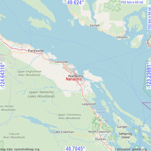
Nanaimo GPS coordinates[2]
49° 9' 58.968" North, 123° 56' 24.108" West
| Map corner | latitude | longitude |
|---|---|---|
| Upper-left | 49.624°, | -124.64316° |
| Center: | 49.16638°, | -123.94003° |
| Lower-right: | 48.7045°, | -123.23691° |
| Map W x H: | 102.2×102.2 km | = 63.5×63.5mi |
| max Lat: | 73.03752° ⇑35.2% North |
| Nanaimo: | 49.16638° |
| min Lat: | ⇓64.8% South 42.05009° |
| min Long | Nanaimo | max Long |
| -139.43328° | -123.94003° | -52.70931° |
| W 3.7%⇐ | ⇒96.3% E |
Elevation
Elevation of Nanaimo is 16 m = 52 ft, and this is 238.4 m = 782 ft below average elevation for this country.
| Max E: |
1518 m = 4980 ft | 89.1% |
| Avg. | 254.4 m = 835 ft | |
| Nanaimo | 16 m = 52 ft | |
Min E: |
-2 m = -7 ft | 10.9% |
See also: Nanaimo elevation on elevation.city.
Geographical zone
Nanaimo is located in North temperate zone (between Tropic of Cancer and the Arctic Circle). Distance of this North polar circle is 1934.4 km =1202 mi to North.| Distance of | km | miles | from Nanaimo |
|---|---|---|---|
| North Pole | 4540.3 | 2821.2 | to North |
| Arctic Circle | 1934.4 | 1202 | to North |
| Tropic Cancer | 2860.9 | 1777.7 | to South |
| Equator | 5466.8 | 3396.9 | to South |


Nearby cities:
15 places around Nanaimo: (largest is in red/bold)
• Cassidy
13.6 km =8.5 mi,  163°
163°
• Cedar
8.4 km =5.2 mi,  131°
131°
• Chemainus
32.1 km =19.9 mi,  149°
149°
• Coombs
37.8 km =23.5 mi,  293°
293°
• East Wellington
5.7 km =3.5 mi,  278°
278°
• Englishman River South
27.9 km =17.3 mi,  297°
297°
• Fairwinds
18.3 km =11.4 mi,  311°
311°
• French Creek
35.9 km =22.3 mi, 302°
• Ladysmith
21.5 km =13.4 mi, 155°
• North Oyster/Yellow Point
15.3 km =9.5 mi, 149°
• Parksville
32.1 km =19.9 mi, 301°
• Saltair
27.1 km =16.8 mi, 152°
• Sechelt
36.7 km =22.8 mi,  20°
20°
• Welcome Beach
35 km =21.7 mi,  5°
5°
• Youbou
38.5 km =23.9 mi,  209°
209°
Sources, notices
• [Note1] Compared only with cities in Canada existing in our database
• [Src1] Map data: © OpenStreetMap contributors (CC-BY-SA)
• [Src2] Other city data from geonames.org with taken over terms of usage.
• [Src3] Geographical zone / Annual Mean Temperature by Robert A. Rohde @ Wikipedia
