Youbou geodata
Youbou (British Columbia) is a populated place; located in Canada in America/Vancouver (GMT-7) time zone. With population of 734 people, there are 1115 cities with bigger population in this country. Compared to other cities in Canada, 60.9% of cities are located further ↓South; 96.8% of cities are located further →East and 52.1% of cities have lower elevation than Youbou. Note1


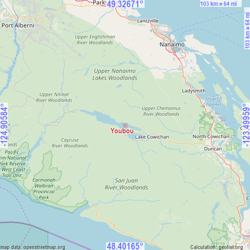
Youbou GPS coordinates[2]
48° 51' 58.752" North, 124° 12' 9.756" West
| Map corner | latitude | longitude |
|---|---|---|
| Upper-left | 49.32671°, | -124.90584° |
| Center: | 48.86632°, | -124.20271° |
| Lower-right: | 48.40165°, | -123.49959° |
| Map W x H: | 102.9×102.9 km | = 63.9×63.9mi |
| max Lat: | 73.03752° ⇑39.1% North |
| Youbou: | 48.86632° |
| min Lat: | ⇓60.9% South 42.05009° |
| min Long | Youbou | max Long |
| -139.43328° | -124.20271° | -52.70931° |
| W 3.2%⇐ | ⇒96.8% E |
Elevation
Elevation of Youbou is 183 m = 600 ft, and this is 71.4 m = 234 ft below average elevation for this country.
| Max E: |
1518 m = 4980 ft | 47.9% |
| Avg. | 254.4 m = 835 ft | |
| Youbou | 183 m = 600 ft | |
Min E: |
-2 m = -7 ft | 52.1% |
See also: Canada elevation on elevation.city.
Geographical zone
Youbou is located in North temperate zone (between Tropic of Cancer and the Arctic Circle). Distance of this North polar circle is 1967.7 km =1222.7 mi to North.| Distance of | km | miles | from Youbou |
|---|---|---|---|
| North Pole | 4573.6 | 2841.9 | to North |
| Arctic Circle | 1967.7 | 1222.7 | to North |
| Tropic Cancer | 2827.5 | 1756.9 | to South |
| Equator | 5433.4 | 3376.2 | to South |


Nearby cities:
15 places around Youbou: (largest is in red/bold)
• Cassidy
30.8 km =19.1 mi,  48°
48°
• Cedar
37.7 km =23.4 mi,  42°
42°
• Chemainus
35.8 km =22.2 mi,  81°
81°
• Cherry Point
50.2 km =31.2 mi,  109°
109°
• Cowichan Bay
45.3 km =28.1 mi, 108°
• Duncan
37.8 km =23.5 mi,  104°
104°
• East Wellington
36.8 km =22.9 mi,  21°
21°
• Englishman River South
46.6 km =29 mi,  352°
352°
• Fairwinds
45.9 km =28.5 mi,  6°
6°
• Ladysmith
31.4 km =19.5 mi,  63°
63°
• Lake Cowichan
11.8 km =7.3 mi, 112°
• Nanaimo
38.5 km =23.9 mi,  29°
29°
• North Cowichan
37.9 km =23.5 mi,  94°
94°
• North Oyster/Yellow Point
33.7 km =20.9 mi, 53°
• Saltair
33 km =20.5 mi,  73°
73°
Sources, notices
• [Note1] Compared only with cities in Canada existing in our database
• [Src1] Map data: © OpenStreetMap contributors (CC-BY-SA)
• [Src2] Other city data from geonames.org with taken over terms of usage.
• [Src3] Geographical zone / Annual Mean Temperature by Robert A. Rohde @ Wikipedia
