Ferme-Neuve geodata
Ferme-Neuve (Quebec) is a populated place; located in Canada in America/Toronto (GMT-4) time zone. With population of 2,115 people, there are 732 cities with bigger population in this country. Compared to other cities in Canada, 53.5% of cities are located further ↑North; 56.8% of cities are located further ←West and 58% of cities have lower elevation than Ferme-Neuve. Note1


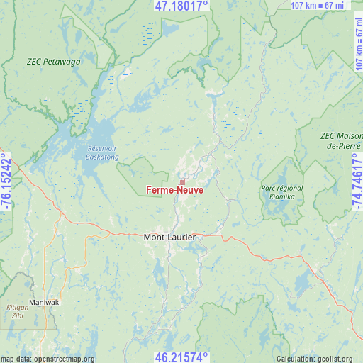
Ferme-Neuve GPS coordinates[2]
46° 42' 0.396" North, 75° 26' 57.444" West
| Map corner | latitude | longitude |
|---|---|---|
| Upper-left | 47.18017°, | -76.15242° |
| Center: | 46.70011°, | -75.44929° |
| Lower-right: | 46.21574°, | -74.74617° |
| Map W x H: | 107.2×107.2 km | = 66.6×66.6mi |
| max Lat: | 73.03752° ⇑53.5% North |
| Ferme-Neuve: | 46.70011° |
| min Lat: | ⇓46.5% South 42.05009° |
| min Long | Ferme-Neuve | max Long |
| -139.43328° | -75.44929° | -52.70931° |
| W 56.8%⇐ | ⇒43.2% E |
Elevation
Elevation of Ferme-Neuve is 219 m = 719 ft, and this is 35.4 m = 116 ft below average elevation for this country.
| Max E: |
1518 m = 4980 ft | 42% |
| Avg. | 254.4 m = 835 ft | |
| Ferme-Neuve | 219 m = 719 ft | |
Min E: |
-2 m = -7 ft | 58% |
See also: Canada elevation on elevation.city.
Geographical zone
Ferme-Neuve is located in North temperate zone (between Tropic of Cancer and the Arctic Circle). Distance of this North polar circle is 2208.6 km =1372.4 mi to North.| Distance of | km | miles | from Ferme-Neuve |
|---|---|---|---|
| North Pole | 4814.5 | 2991.6 | to North |
| Arctic Circle | 2208.6 | 1372.4 | to North |
| Tropic Cancer | 2586.6 | 1607.2 | to South |
| Equator | 5192.6 | 3226.5 | to South |


Nearby cities:
15 places around Ferme-Neuve: (largest is in red/bold)
• Kazabazua
94.1 km =58.5 mi,  207°
207°
• La Conception
83.9 km =52.1 mi,  136°
136°
• La Minerve
63.8 km =39.6 mi, 141°
• Labelle
71.8 km =44.6 mi,  130°
130°
• Lac-Simon
81.2 km =50.5 mi, 138°
• Manawan
99.3 km =61.7 mi,  54°
54°
• Maniwaki
52.9 km =32.9 mi,  228°
228°
• Mont-Laurier
17.1 km =10.6 mi,  192°
192°
• Mont-Tremblant
85.6 km =53.2 mi, 129°
• Notre-Dame-du-Mont-Carmel
81 km =50.3 mi,  159°
159°
• Rivière-Rouge
54.6 km =33.9 mi, 125°
• Saint-Boniface
46.4 km =28.8 mi,  241°
241°
• Saint-Faustin
98.5 km =61.2 mi, 131°
• Saint-Raphaël
66.2 km =41.1 mi,  220°
220°
• Saint-Émile-de-Suffolk
94.6 km =58.8 mi,  154°
154°
Sources, notices
• [Note1] Compared only with cities in Canada existing in our database
• [Src1] Map data: © OpenStreetMap contributors (CC-BY-SA)
• [Src2] Other city data from geonames.org with taken over terms of usage.
• [Src3] Geographical zone / Annual Mean Temperature by Robert A. Rohde @ Wikipedia
