Tofield geodata
Tofield (Alberta) is a populated place; located in Canada in America/Edmonton (GMT-6) time zone. With population of 1,911 people, there are 765 cities with bigger population in this country. Compared to other cities in Canada, 90.7% of cities are located further ↓South; 77.2% of cities are located further →East and 91.7% of cities have lower elevation than Tofield. Note1


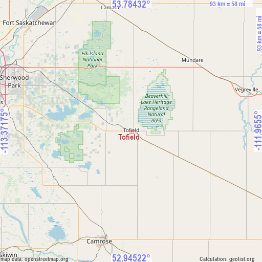
Tofield GPS coordinates[2]
53° 22' 0.624" North, 112° 40' 7.032" West
| Map corner | latitude | longitude |
|---|---|---|
| Upper-left | 53.78432°, | -113.37175° |
| Center: | 53.36684°, | -112.66862° |
| Lower-right: | 52.94522°, | -111.9655° |
| Map W x H: | 93.3×93.3 km | = 58×58mi |
| max Lat: | 73.03752° ⇑9.3% North |
| Tofield: | 53.36684° |
| min Lat: | ⇓90.7% South 42.05009° |
| min Long | Tofield | max Long |
| -139.43328° | -112.66862° | -52.70931° |
| W 22.8%⇐ | ⇒77.2% E |
Elevation
Elevation of Tofield is 697 m = 2287 ft, and this is 442.6 m = 1452 ft above average elevation for this country.
| Max E: |
1518 m = 4980 ft | 8.3% |
| Tofield | 697 m 2287 ft | |
| Avg. | 254.4 m = 835 ft | |
Min E: |
-2 m = -7 ft | 91.7% |
See also: Canada elevation on elevation.city.
Geographical zone
Tofield is located in North temperate zone (between Tropic of Cancer and the Arctic Circle). Distance of this North polar circle is 1467.3 km =911.7 mi to North.| Distance of | km | miles | from Tofield |
|---|---|---|---|
| North Pole | 4073.2 | 2531 | to North |
| Arctic Circle | 1467.3 | 911.7 | to North |
| Tropic Cancer | 3327.9 | 2067.9 | to South |
| Equator | 5933.8 | 3687.1 | to South |


Nearby cities:
15 places around Tofield: (largest is in red/bold)
• Beaumont
49.8 km =30.9 mi,  267°
267°
• Camrose
40.5 km =25.2 mi,  195°
195°
• Edmonton
56.8 km =35.3 mi,  291°
291°
• Fort Saskatchewan
53.2 km =33.1 mi,  316°
316°
• Lamont
45.3 km =28.1 mi,  348°
348°
• Larkspur
48.9 km =30.4 mi,  284°
284°
• Laurel
48.1 km =29.9 mi, 280°
• Maple Ridge
48.4 km =30.1 mi, 288°
• Mill Woods Town Centre
51.3 km =31.9 mi, 281°
• Rideau Park
56.8 km =35.3 mi, 282°
• Sherwood Park
46.2 km =28.7 mi, 291°
• Silver Berry
48.3 km =30 mi, 282°
• Tamarack
47.2 km =29.3 mi, 283°
• Vegreville
43.5 km =27 mi,  70°
70°
• Wild Rose
48.6 km =30.2 mi, 283°
Sources, notices
• [Note1] Compared only with cities in Canada existing in our database
• [Src1] Map data: © OpenStreetMap contributors (CC-BY-SA)
• [Src2] Other city data from geonames.org with taken over terms of usage.
• [Src3] Geographical zone / Annual Mean Temperature by Robert A. Rohde @ Wikipedia
