Lumsden geodata
Lumsden (Saskatchewan) is a populated place; located in Canada in America/Regina (GMT-6) time zone. With population of 1,477 people, there are 869 cities with bigger population in this country. Compared to other cities in Canada, 80.4% of cities are located further ↓South; 72% of cities are located further →East and 81.6% of cities have lower elevation than Lumsden. Note1


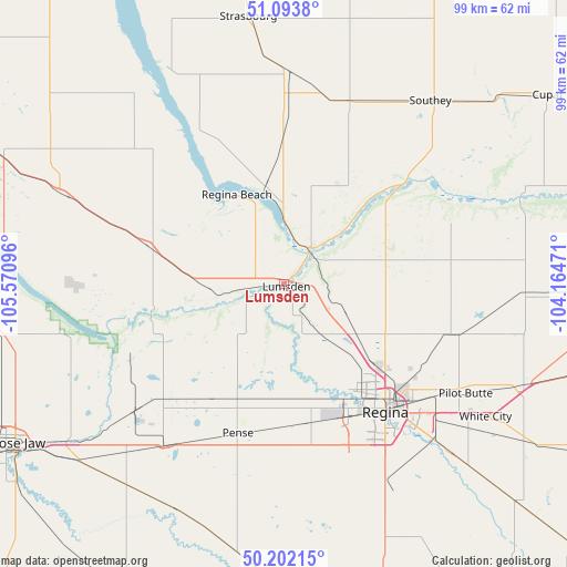
Lumsden GPS coordinates[2]
50° 39' 0.324" North, 104° 52' 4.188" West
| Map corner | latitude | longitude |
|---|---|---|
| Upper-left | 51.0938°, | -105.57096° |
| Center: | 50.65009°, | -104.86783° |
| Lower-right: | 50.20215°, | -104.16471° |
| Map W x H: | 99.1×99.1 km | = 61.6×61.6mi |
| max Lat: | 73.03752° ⇑19.6% North |
| Lumsden: | 50.65009° |
| min Lat: | ⇓80.4% South 42.05009° |
| min Long | Lumsden | max Long |
| -139.43328° | -104.86783° | -52.70931° |
| W 28%⇐ | ⇒72% E |
Elevation
Elevation of Lumsden is 496 m = 1627 ft, and this is 241.6 m = 793 ft above average elevation for this country.
| Max E: |
1518 m = 4980 ft | 18.4% |
| Lumsden | 496 m 1627 ft | |
| Avg. | 254.4 m = 835 ft | |
Min E: |
-2 m = -7 ft | 81.6% |
See also: Canada elevation on elevation.city.
Geographical zone
Lumsden is located in North temperate zone (between Tropic of Cancer and the Arctic Circle). Distance of this North polar circle is 1769.4 km =1099.5 mi to North.| Distance of | km | miles | from Lumsden |
|---|---|---|---|
| North Pole | 4375.3 | 2718.7 | to North |
| Arctic Circle | 1769.4 | 1099.5 | to North |
| Tropic Cancer | 3025.8 | 1880.1 | to South |
| Equator | 5631.8 | 3499.4 | to South |


Nearby cities:
15 places around Lumsden: (largest is in red/bold)
• Assiniboia
138.2 km =85.9 mi,  215°
215°
• Caronport
70.7 km =43.9 mi,  251°
251°
• Davidson
104 km =64.6 mi,  311°
311°
• Foam Lake
144.9 km =90 mi,  39°
39°
• Grenfell
139.1 km =86.4 mi,  100°
100°
• Indian Head
85.7 km =53.3 mi, 98°
• Lanigan
133.9 km =83.2 mi,  355°
355°
• Moose Jaw
54.7 km =34 mi,  239°
239°
• Pilot Butte
37.8 km =23.5 mi,  122°
122°
• Regina
28.4 km =17.6 mi,  141°
141°
• Regina Beach
17.5 km =10.9 mi,  327°
327°
• Watrous
120.5 km =74.9 mi,  339°
339°
• Weyburn
131.1 km =81.5 mi,  146°
146°
• White City
42.8 km =26.6 mi, 124°
• Wynyard
133 km =82.6 mi,  20°
20°
Sources, notices
• [Note1] Compared only with cities in Canada existing in our database
• [Src1] Map data: © OpenStreetMap contributors (CC-BY-SA)
• [Src2] Other city data from geonames.org with taken over terms of usage.
• [Src3] Geographical zone / Annual Mean Temperature by Robert A. Rohde @ Wikipedia
