Regina geodata
Regina (Saskatchewan) is a seat of a first-order administrative division; located in Canada in America/Regina (GMT-6) time zone. With population of 176,183 people, there are 34 cities with bigger population in this country. Compared to other cities in Canada, 79.1% of cities are located further ↓South; 71.9% of cities are located further →East and 85.3% of cities have lower elevation than Regina. Note1


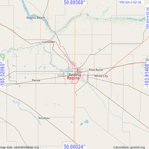
Regina GPS coordinates[2]
50° 27' 0.288" North, 104° 37' 4.08" West
| Map corner | latitude | longitude |
|---|---|---|
| Upper-left | 50.89568°, | -105.32093° |
| Center: | 50.45008°, | -104.6178° |
| Lower-right: | 50.00024°, | -103.91468° |
| Map W x H: | 99.6×99.6 km | = 61.9×61.9mi |
| max Lat: | 73.03752° ⇑20.9% North |
| Regina: | 50.45008° |
| min Lat: | ⇓79.1% South 42.05009° |
| min Long | Regina | max Long |
| -139.43328° | -104.6178° | -52.70931° |
| W 28.1%⇐ | ⇒71.9% E |
Elevation
Elevation of Regina is 577 m = 1893 ft, and this is 322.6 m = 1058 ft above average elevation for this country.
| Max E: |
1518 m = 4980 ft | 14.7% |
| Regina | 577 m 1893 ft | |
| Avg. | 254.4 m = 835 ft | |
Min E: |
-2 m = -7 ft | 85.3% |
See also: Regina elevation on elevation.city.
Geographical zone
Regina is located in North temperate zone (between Tropic of Cancer and the Arctic Circle). Distance of this North polar circle is 1791.7 km =1113.3 mi to North.| Distance of | km | miles | from Regina |
|---|---|---|---|
| North Pole | 4397.5 | 2732.5 | to North |
| Arctic Circle | 1791.7 | 1113.3 | to North |
| Tropic Cancer | 3003.6 | 1866.3 | to South |
| Equator | 5609.5 | 3485.6 | to South |


Nearby cities:
15 places around Regina: (largest is in red/bold)
• Assiniboia
133.3 km =82.8 mi,  227°
227°
• Caronport
85 km =52.8 mi,  269°
269°
• Davidson
132.1 km =82.1 mi,  313°
313°
• Grenfell
119.3 km =74.1 mi,  91°
91°
• Indian Head
67.8 km =42.1 mi,  82°
82°
• Kipling
146.2 km =90.8 mi,  105°
105°
• Lumsden
28.4 km =17.6 mi,  321°
321°
• Melville
138.1 km =85.8 mi,  67°
67°
• Moose Jaw
65.2 km =40.5 mi, 265°
• Pilot Butte
14.3 km =8.9 mi, 82°
• Regina Beach
45.9 km =28.5 mi, 323°
• Watrous
147.8 km =91.8 mi,  336°
336°
• Weyburn
102.9 km =63.9 mi,  147°
147°
• White City
17.8 km =11.1 mi,  95°
95°
• Wynyard
149.5 km =92.9 mi,  11°
11°
Sources, notices
• [Note1] Compared only with cities in Canada existing in our database
• [Src1] Map data: © OpenStreetMap contributors (CC-BY-SA)
• [Src2] Other city data from geonames.org with taken over terms of usage.
• [Src3] Geographical zone / Annual Mean Temperature by Robert A. Rohde @ Wikipedia
