Lanigan geodata
Lanigan (Saskatchewan) is a populated place; located in Canada in America/Regina (GMT-6) time zone. With population of 1,204 people, there are 951 cities with bigger population in this country. Compared to other cities in Canada, 85.5% of cities are located further ↓South; 72.1% of cities are located further →East and 83.4% of cities have lower elevation than Lanigan. Note1


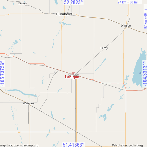
Lanigan GPS coordinates[2]
51° 51' 0.216" North, 105° 2' 3.948" West
| Map corner | latitude | longitude |
|---|---|---|
| Upper-left | 52.2823°, | -105.73756° |
| Center: | 51.85006°, | -105.03443° |
| Lower-right: | 51.41363°, | -104.33131° |
| Map W x H: | 96.6×96.6 km | = 60×60mi |
| max Lat: | 73.03752° ⇑14.5% North |
| Lanigan: | 51.85006° |
| min Lat: | ⇓85.5% South 42.05009° |
| min Long | Lanigan | max Long |
| -139.43328° | -105.03443° | -52.70931° |
| W 27.9%⇐ | ⇒72.1% E |
Elevation
Elevation of Lanigan is 534 m = 1752 ft, and this is 279.6 m = 917 ft above average elevation for this country.
| Max E: |
1518 m = 4980 ft | 16.6% |
| Lanigan | 534 m 1752 ft | |
| Avg. | 254.4 m = 835 ft | |
Min E: |
-2 m = -7 ft | 83.4% |
See also: Canada elevation on elevation.city.
Geographical zone
Lanigan is located in North temperate zone (between Tropic of Cancer and the Arctic Circle). Distance of this North polar circle is 1636 km =1016.6 mi to North.| Distance of | km | miles | from Lanigan |
|---|---|---|---|
| North Pole | 4241.9 | 2635.8 | to North |
| Arctic Circle | 1636 | 1016.6 | to North |
| Tropic Cancer | 3159.3 | 1963.1 | to South |
| Equator | 5765.2 | 3582.3 | to South |


Nearby cities:
15 places around Lanigan: (largest is in red/bold)
• Dalmeny
130 km =80.8 mi,  294°
294°
• Davidson
92.3 km =57.4 mi,  225°
225°
• Foam Lake
105.6 km =65.6 mi,  102°
102°
• Humboldt
39.4 km =24.5 mi,  350°
350°
• Kelvington
108.5 km =67.4 mi,  71°
71°
• Martensville
121.6 km =75.6 mi, 293°
• Melfort
116.5 km =72.4 mi,  14°
14°
• Regina Beach
118.6 km =73.7 mi,  178°
178°
• Rosthern
126.8 km =78.8 mi,  315°
315°
• Saskatoon
116.2 km =72.2 mi, 285°
• Tisdale
129.7 km =80.6 mi,  30°
30°
• Wadena
85.3 km =53 mi,  82°
82°
• Warman
116.9 km =72.6 mi,  296°
296°
• Watrous
36.1 km =22.4 mi,  235°
235°
• Wynyard
59.2 km =36.8 mi, 99°
Sources, notices
• [Note1] Compared only with cities in Canada existing in our database
• [Src1] Map data: © OpenStreetMap contributors (CC-BY-SA)
• [Src2] Other city data from geonames.org with taken over terms of usage.
• [Src3] Geographical zone / Annual Mean Temperature by Robert A. Rohde @ Wikipedia
