Wynyard geodata
Wynyard (Saskatchewan) is a populated place; located in Canada in America/Regina (GMT-6) time zone. With population of 1,793 people, there are 794 cities with bigger population in this country. Compared to other cities in Canada, 85.3% of cities are located further ↓South; 71.5% of cities are located further →East and 84.7% of cities have lower elevation than Wynyard. Note1


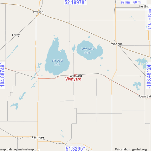
Wynyard GPS coordinates[2]
51° 46' 0.264" North, 104° 11' 3.696" West
| Map corner | latitude | longitude |
|---|---|---|
| Upper-left | 52.19978°, | -104.88749° |
| Center: | 51.76674°, | -104.18436° |
| Lower-right: | 51.3295°, | -103.48124° |
| Map W x H: | 96.8×96.8 km | = 60.1×60.1mi |
| max Lat: | 73.03752° ⇑14.7% North |
| Wynyard: | 51.76674° |
| min Lat: | ⇓85.3% South 42.05009° |
| min Long | Wynyard | max Long |
| -139.43328° | -104.18436° | -52.70931° |
| W 28.5%⇐ | ⇒71.5% E |
Elevation
Elevation of Wynyard is 559 m = 1834 ft, and this is 304.6 m = 999 ft above average elevation for this country.
| Max E: |
1518 m = 4980 ft | 15.3% |
| Wynyard | 559 m 1834 ft | |
| Avg. | 254.4 m = 835 ft | |
Min E: |
-2 m = -7 ft | 84.7% |
See also: Canada elevation on elevation.city.
Geographical zone
Wynyard is located in North temperate zone (between Tropic of Cancer and the Arctic Circle). Distance of this North polar circle is 1645.3 km =1022.3 mi to North.| Distance of | km | miles | from Wynyard |
|---|---|---|---|
| North Pole | 4251.1 | 2641.5 | to North |
| Arctic Circle | 1645.3 | 1022.3 | to North |
| Tropic Cancer | 3150 | 1957.3 | to South |
| Equator | 5755.9 | 3576.5 | to South |


Nearby cities:
15 places around Wynyard: (largest is in red/bold)
• Canora
121.5 km =75.5 mi,  97°
97°
• Davidson
136.4 km =84.8 mi,  245°
245°
• Foam Lake
46.6 km =29 mi,  106°
106°
• Humboldt
80.5 km =50 mi,  306°
306°
• Kelvington
62.9 km =39.1 mi,  45°
45°
• Lanigan
59.2 km =36.8 mi,  279°
279°
• Lumsden
133 km =82.6 mi,  200°
200°
• Melfort
125.8 km =78.2 mi,  346°
346°
• Melville
134.8 km =83.8 mi,  134°
134°
• Preeceville
106.1 km =65.9 mi,  78°
78°
• Regina Beach
123.2 km =76.6 mi,  207°
207°
• Tisdale
120.8 km =75.1 mi,  4°
4°
• Wadena
33.3 km =20.7 mi, 52°
• Watrous
89.1 km =55.4 mi,  262°
262°
• Yorkton
133.7 km =83.1 mi,  117°
117°
Sources, notices
• [Note1] Compared only with cities in Canada existing in our database
• [Src1] Map data: © OpenStreetMap contributors (CC-BY-SA)
• [Src2] Other city data from geonames.org with taken over terms of usage.
• [Src3] Geographical zone / Annual Mean Temperature by Robert A. Rohde @ Wikipedia
