Grenfell geodata
Grenfell (Saskatchewan) is a populated place; located in Canada in America/Regina (GMT-6) time zone. With population of 997 people, there are 1046 cities with bigger population in this country. Compared to other cities in Canada, 78.8% of cities are located further ↓South; 70.7% of cities are located further →East and 86.4% of cities have lower elevation than Grenfell. Note1


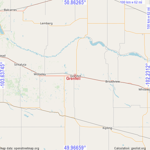
Grenfell GPS coordinates[2]
50° 25' 0.264" North, 102° 56' 3.552" West
| Map corner | latitude | longitude |
|---|---|---|
| Upper-left | 50.86265°, | -103.63745° |
| Center: | 50.41674°, | -102.93432° |
| Lower-right: | 49.96659°, | -102.2312° |
| Map W x H: | 99.6×99.6 km | = 61.9×61.9mi |
| max Lat: | 73.03752° ⇑21.2% North |
| Grenfell: | 50.41674° |
| min Lat: | ⇓78.8% South 42.05009° |
| min Long | Grenfell | max Long |
| -139.43328° | -102.93432° | -52.70931° |
| W 29.3%⇐ | ⇒70.7% E |
Elevation
Elevation of Grenfell is 595 m = 1952 ft, and this is 340.6 m = 1117 ft above average elevation for this country.
| Max E: |
1518 m = 4980 ft | 13.6% |
| Grenfell | 595 m 1952 ft | |
| Avg. | 254.4 m = 835 ft | |
Min E: |
-2 m = -7 ft | 86.4% |
See also: Canada elevation on elevation.city.
Geographical zone
Grenfell is located in North temperate zone (between Tropic of Cancer and the Arctic Circle). Distance of this North polar circle is 1795.4 km =1115.6 mi to North.| Distance of | km | miles | from Grenfell |
|---|---|---|---|
| North Pole | 4401.2 | 2734.8 | to North |
| Arctic Circle | 1795.4 | 1115.6 | to North |
| Tropic Cancer | 2999.9 | 1864.1 | to South |
| Equator | 5605.8 | 3483.3 | to South |


Nearby cities:
15 places around Grenfell: (largest is in red/bold)
• Canora
139.7 km =86.8 mi,  14°
14°
• Carlyle
99.3 km =61.7 mi,  151°
151°
• Esterhazy
65.4 km =40.6 mi,  66°
66°
• Indian Head
53.5 km =33.2 mi,  284°
284°
• Kipling
41.2 km =25.6 mi, 148°
• Langenburg
98.4 km =61.1 mi,  60°
60°
• Lumsden
139.1 km =86.4 mi, 280°
• Melville
56.4 km =35 mi, 9°
• Moosomin
95.4 km =59.3 mi,  109°
109°
• Oxbow
142.6 km =88.6 mi,  157°
157°
• Pilot Butte
105.2 km =65.4 mi,  273°
273°
• Regina
119.3 km =74.1 mi, 271°
• Weyburn
106 km =65.9 mi,  218°
218°
• White City
101.6 km =63.1 mi, 271°
• Yorkton
94.8 km =58.9 mi,  20°
20°
Sources, notices
• [Note1] Compared only with cities in Canada existing in our database
• [Src1] Map data: © OpenStreetMap contributors (CC-BY-SA)
• [Src2] Other city data from geonames.org with taken over terms of usage.
• [Src3] Geographical zone / Annual Mean Temperature by Robert A. Rohde @ Wikipedia
