Mayerthorpe geodata
Mayerthorpe (Alberta) is a populated place; located in Canada in America/Edmonton (GMT-6) time zone. With population of 1,651 people, there are 826 cities with bigger population in this country. Compared to other cities in Canada, 93.1% of cities are located further ↓South; 83.3% of cities are located further →East and 92.7% of cities have lower elevation than Mayerthorpe. Note1


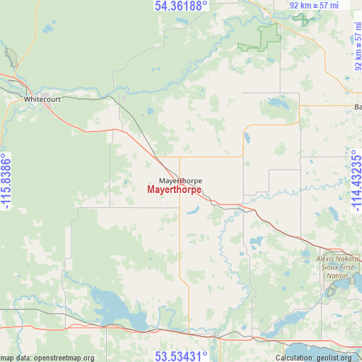
Mayerthorpe GPS coordinates[2]
53° 57' 0.54" North, 115° 8' 7.692" West
| Map corner | latitude | longitude |
|---|---|---|
| Upper-left | 54.36188°, | -115.8386° |
| Center: | 53.95015°, | -115.13547° |
| Lower-right: | 53.53431°, | -114.43235° |
| Map W x H: | 92×92 km | = 57.2×57.2mi |
| max Lat: | 73.03752° ⇑6.9% North |
| Mayerthorpe: | 53.95015° |
| min Lat: | ⇓93.1% South 42.05009° |
| min Long | Mayerthorpe | max Long |
| -139.43328° | -115.13547° | -52.70931° |
| W 16.7%⇐ | ⇒83.3% E |
Elevation
Elevation of Mayerthorpe is 716 m = 2349 ft, and this is 461.6 m = 1514 ft above average elevation for this country.
| Max E: |
1518 m = 4980 ft | 7.3% |
| Mayerthorpe | 716 m 2349 ft | |
| Avg. | 254.4 m = 835 ft | |
Min E: |
-2 m = -7 ft | 92.7% |
See also: Canada elevation on elevation.city.
Geographical zone
Mayerthorpe is located in North temperate zone (between Tropic of Cancer and the Arctic Circle). Distance of this North polar circle is 1402.5 km =871.5 mi to North.| Distance of | km | miles | from Mayerthorpe |
|---|---|---|---|
| North Pole | 4008.4 | 2490.7 | to North |
| Arctic Circle | 1402.5 | 871.5 | to North |
| Tropic Cancer | 3392.8 | 2108.2 | to South |
| Equator | 5998.7 | 3727.4 | to South |


Nearby cities:
15 places around Mayerthorpe: (largest is in red/bold)
• Barrhead
52 km =32.3 mi,  66°
66°
• Bon Accord
113.2 km =70.3 mi,  96°
96°
• Calmar
115.4 km =71.7 mi,  131°
131°
• Devon
112.8 km =70.1 mi, 125°
• Drayton Valley
82.1 km =51 mi,  173°
173°
• Edmonton
118.3 km =73.5 mi,  112°
112°
• Edson
94.7 km =58.8 mi,  244°
244°
• Gibbons
118.7 km =73.8 mi, 96°
• Morinville
98.7 km =61.3 mi, 99°
• Spruce Grove
92.5 km =57.5 mi,  120°
120°
• St. Albert
104.6 km =65 mi, 109°
• Stony Plain
87.8 km =54.6 mi, 121°
• Swan Hills
87 km =54.1 mi,  348°
348°
• Westlock
85.6 km =53.2 mi, 74°
• Whitecourt
42.2 km =26.2 mi,  301°
301°
Sources, notices
• [Note1] Compared only with cities in Canada existing in our database
• [Src1] Map data: © OpenStreetMap contributors (CC-BY-SA)
• [Src2] Other city data from geonames.org with taken over terms of usage.
• [Src3] Geographical zone / Annual Mean Temperature by Robert A. Rohde @ Wikipedia
