Edson geodata
Edson (Alberta) is a populated place; located in Canada in America/Edmonton (GMT-6) time zone. With population of 7,975 people, there are 368 cities with bigger population in this country. Compared to other cities in Canada, 92.1% of cities are located further ↓South; 84.3% of cities are located further →East and 96.2% of cities have lower elevation than Edson. Note1


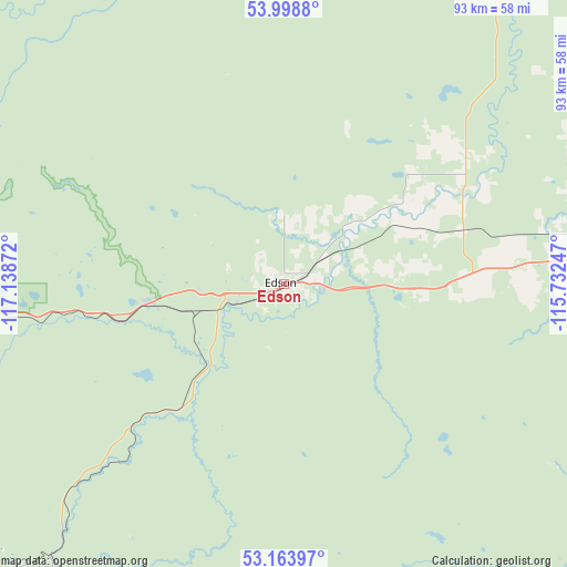
Edson GPS coordinates[2]
53° 35' 0.42" North, 116° 26' 8.124" West
| Map corner | latitude | longitude |
|---|---|---|
| Upper-left | 53.9988°, | -117.13872° |
| Center: | 53.58345°, | -116.43559° |
| Lower-right: | 53.16397°, | -115.73247° |
| Map W x H: | 92.8×92.8 km | = 57.7×57.7mi |
| max Lat: | 73.03752° ⇑7.9% North |
| Edson: | 53.58345° |
| min Lat: | ⇓92.1% South 42.05009° |
| min Long | Edson | max Long |
| -139.43328° | -116.43559° | -52.70931° |
| W 15.7%⇐ | ⇒84.3% E |
Elevation
Elevation of Edson is 913 m = 2995 ft, and this is 658.6 m = 2161 ft above average elevation for this country.
| Max E: |
1518 m = 4980 ft | 3.8% |
| Edson | 913 m 2995 ft | |
| Avg. | 254.4 m = 835 ft | |
Min E: |
-2 m = -7 ft | 96.2% |
See also: Canada elevation on elevation.city.
Geographical zone
Edson is located in North temperate zone (between Tropic of Cancer and the Arctic Circle). Distance of this North polar circle is 1443.3 km =896.8 mi to North.| Distance of | km | miles | from Edson |
|---|---|---|---|
| North Pole | 4049.1 | 2516 | to North |
| Arctic Circle | 1443.3 | 896.8 | to North |
| Tropic Cancer | 3352 | 2082.8 | to South |
| Equator | 5957.9 | 3702.1 | to South |


Nearby cities:
15 places around Edson: (largest is in red/bold)
• Barrhead
146.7 km =91.2 mi,  65°
65°
• Calmar
176.9 km =109.9 mi,  101°
101°
• Drayton Valley
104.4 km =64.9 mi,  112°
112°
• Fox Creek
93.9 km =58.3 mi,  345°
345°
• Hinton
78.8 km =49 mi,  254°
254°
• Jasper
134.6 km =83.6 mi,  234°
234°
• Jasper Park Lodge
132.8 km =82.5 mi, 234°
• Mayerthorpe
94.7 km =58.8 mi,  64°
64°
• Rocky Mountain House
169.1 km =105.1 mi,  143°
143°
• Spruce Grove
166.3 km =103.3 mi,  91°
91°
• Stony Plain
160.8 km =99.9 mi, 91°
• Swan Hills
142.9 km =88.8 mi,  28°
28°
• Valleyview
173.9 km =108.1 mi,  341°
341°
• Westlock
179.7 km =111.7 mi, 69°
• Whitecourt
79.9 km =49.6 mi,  37°
37°
Sources, notices
• [Note1] Compared only with cities in Canada existing in our database
• [Src1] Map data: © OpenStreetMap contributors (CC-BY-SA)
• [Src2] Other city data from geonames.org with taken over terms of usage.
• [Src3] Geographical zone / Annual Mean Temperature by Robert A. Rohde @ Wikipedia
