Louiseville geodata
Louiseville (Quebec) is a populated place; located in Canada in America/Toronto (GMT-4) time zone. With population of 5,819 people, there are 436 cities with bigger population in this country. Compared to other cities in Canada, 58.1% of cities are located further ↑North; 72.6% of cities are located further ←West and 88.3% of cities have higher elevation than Louiseville. Note1


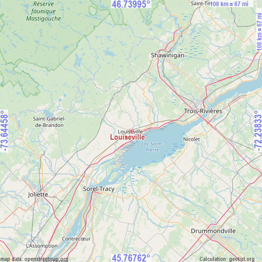
Louiseville GPS coordinates[2]
46° 15' 21.384" North, 72° 56' 29.22" West
| Map corner | latitude | longitude |
|---|---|---|
| Upper-left | 46.73995°, | -73.64458° |
| Center: | 46.25594°, | -72.94145° |
| Lower-right: | 45.76762°, | -72.23833° |
| Map W x H: | 108.1×108.1 km | = 67.2×67.2mi |
| max Lat: | 73.03752° ⇑58.1% North |
| Louiseville: | 46.25594° |
| min Lat: | ⇓41.9% South 42.05009° |
| min Long | Louiseville | max Long |
| -139.43328° | -72.94145° | -52.70931° |
| W 72.6%⇐ | ⇒27.4% E |
Elevation
Elevation of Louiseville is 17 m = 56 ft, and this is 237.4 m = 779 ft below average elevation for this country.
| Max E: |
1518 m = 4980 ft | 88.3% |
| Avg. | 254.4 m = 835 ft | |
| Louiseville | 17 m = 56 ft | |
Min E: |
-2 m = -7 ft | 11.7% |
See also: Canada elevation on elevation.city.
Geographical zone
Louiseville is located in North temperate zone (between Tropic of Cancer and the Arctic Circle). Distance of this North polar circle is 2258 km =1403.1 mi to North.| Distance of | km | miles | from Louiseville |
|---|---|---|---|
| North Pole | 4863.9 | 3022.3 | to North |
| Arctic Circle | 2258 | 1403.1 | to North |
| Tropic Cancer | 2537.3 | 1576.6 | to South |
| Equator | 5143.2 | 3195.8 | to South |


Nearby cities:
15 places around Louiseville: (largest is in red/bold)
• Berthierville
26.7 km =16.6 mi,  224°
224°
• Mandeville
33.7 km =20.9 mi,  291°
291°
• Maskinongé
6.7 km =4.2 mi,  243°
243°
• Nicolet
25.4 km =15.8 mi,  99°
99°
• Pierreville
22.9 km =14.2 mi,  154°
154°
• Saint-Félix-de-Valois
38.4 km =23.9 mi,  255°
255°
• Saint-Gabriel
34.2 km =21.3 mi,  278°
278°
• Saint-Norbert
30.3 km =18.8 mi,  251°
251°
• Saint-Pie-V
31.8 km =19.8 mi, 151°
• Sainte-Catherine
29.6 km =18.4 mi,  76°
76°
• Sainte-Élisabeth
36.3 km =22.6 mi, 240°
• Shawinigan
37.6 km =23.4 mi,  23°
23°
• Sorel-Tracy
27.3 km =17 mi,  209°
209°
• Trois-Rivières
31.8 km =19.8 mi,  71°
71°
• Yamachiche
8.5 km =5.3 mi, 81°
Sources, notices
• [Note1] Compared only with cities in Canada existing in our database
• [Src1] Map data: © OpenStreetMap contributors (CC-BY-SA)
• [Src2] Other city data from geonames.org with taken over terms of usage.
• [Src3] Geographical zone / Annual Mean Temperature by Robert A. Rohde @ Wikipedia
