Shawinigan geodata
Shawinigan (Quebec) is a seat of a third-order administrative division; located in Canada in America/Toronto (GMT-4) time zone. With population of 38,211 people, there are 123 cities with bigger population in this country. Compared to other cities in Canada, 55.1% of cities are located further ↑North; 73.5% of cities are located further ←West and 56.9% of cities have higher elevation than Shawinigan. Note1


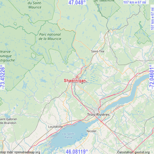
Shawinigan GPS coordinates[2]
46° 34' 0.3" North, 72° 44' 56.868" West
| Map corner | latitude | longitude |
|---|---|---|
| Upper-left | 47.048°, | -73.45226° |
| Center: | 46.56675°, | -72.74913° |
| Lower-right: | 46.08119°, | -72.04601° |
| Map W x H: | 107.5×107.5 km | = 66.8×66.8mi |
| max Lat: | 73.03752° ⇑55.1% North |
| Shawinigan: | 46.56675° |
| min Lat: | ⇓44.9% South 42.05009° |
| min Long | Shawinigan | max Long |
| -139.43328° | -72.74913° | -52.70931° |
| W 73.5%⇐ | ⇒26.5% E |
Elevation
Elevation of Shawinigan is 123 m = 404 ft, and this is 131.4 m = 431 ft below average elevation for this country.
| Max E: |
1518 m = 4980 ft | 56.9% |
| Avg. | 254.4 m = 835 ft | |
| Shawinigan | 123 m = 404 ft | |
Min E: |
-2 m = -7 ft | 43.1% |
See also: Canada elevation on elevation.city.
Geographical zone
Shawinigan is located in North temperate zone (between Tropic of Cancer and the Arctic Circle). Distance of this North polar circle is 2223.4 km =1381.6 mi to North.| Distance of | km | miles | from Shawinigan |
|---|---|---|---|
| North Pole | 4829.3 | 3000.8 | to North |
| Arctic Circle | 2223.4 | 1381.6 | to North |
| Tropic Cancer | 2571.8 | 1598 | to South |
| Equator | 5177.7 | 3217.3 | to South |


Nearby cities:
15 places around Shawinigan: (largest is in red/bold)
• Bécancour
34.9 km =21.7 mi,  135°
135°
• Hérouxville
14.6 km =9.1 mi,  40°
40°
• Louiseville
37.6 km =23.4 mi,  203°
203°
• Mandeville
51 km =31.7 mi,  244°
244°
• Maskinongé
42.9 km =26.7 mi,  208°
208°
• Nicolet
40.2 km =25 mi,  165°
165°
• Pierreville
55.4 km =34.4 mi,  184°
184°
• Saint-Gabriel
56.9 km =35.4 mi, 238°
• Saint-Marc-des-Carrières
55 km =34.2 mi,  76°
76°
• Saint-Pierre-les-Becquets
42.7 km =26.5 mi,  99°
99°
• Saint-Tite
23.2 km =14.4 mi, 37°
• Sainte-Catherine
31 km =19.3 mi,  153°
153°
• Sainte-Thècle
33.7 km =20.9 mi,  34°
34°
• Trois-Rivières
29.1 km =18.1 mi, 147°
• Yamachiche
34 km =21.1 mi,  190°
190°
Sources, notices
• [Note1] Compared only with cities in Canada existing in our database
• [Src1] Map data: © OpenStreetMap contributors (CC-BY-SA)
• [Src2] Other city data from geonames.org with taken over terms of usage.
• [Src3] Geographical zone / Annual Mean Temperature by Robert A. Rohde @ Wikipedia
