Sainte-Catherine geodata
Sainte-Catherine (Quebec) is a populated place; located in Canada in America/Toronto (GMT-4) time zone. With population of 16,211 people, there are 225 cities with bigger population in this country. Compared to other cities in Canada, 57.2% of cities are located further ↑North; 74.2% of cities are located further ←West and 93.8% of cities have higher elevation than Sainte-Catherine. Note1


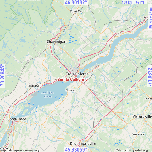
Sainte-Catherine GPS coordinates[2]
46° 19' 6.096" North, 72° 33' 58.752" West
| Map corner | latitude | longitude |
|---|---|---|
| Upper-left | 46.80182°, | -73.26945° |
| Center: | 46.31836°, | -72.56632° |
| Lower-right: | 45.83059°, | -71.8632° |
| Map W x H: | 108×108 km | = 67.1×67.1mi |
| max Lat: | 73.03752° ⇑57.2% North |
| Sainte-Catherine: | 46.31836° |
| min Lat: | ⇓42.8% South 42.05009° |
| min Long | Sainte-Catherin | max Long |
| -139.43328° | -72.56632° | -52.70931° |
| W 74.2%⇐ | ⇒25.8% E |
Elevation
Elevation of Sainte-Catherine is 10 m = 33 ft, and this is 244.4 m = 802 ft below average elevation for this country.
| Max E: |
1518 m = 4980 ft | 93.8% |
| Avg. | 254.4 m = 835 ft | |
| Sainte-Catherine | 10 m = 33 ft | |
Min E: |
-2 m = -7 ft | 6.2% |
See also: Canada elevation on elevation.city.
Geographical zone
Sainte-Catherine is located in North temperate zone (between Tropic of Cancer and the Arctic Circle). Distance of this North polar circle is 2251.1 km =1398.8 mi to North.| Distance of | km | miles | from Sainte-Catherine |
|---|---|---|---|
| North Pole | 4856.9 | 3017.9 | to North |
| Arctic Circle | 2251.1 | 1398.8 | to North |
| Tropic Cancer | 2544.2 | 1580.9 | to South |
| Equator | 5150.1 | 3200.1 | to South |


Nearby cities:
15 places around Sainte-Catherine: (largest is in red/bold)
• Bécancour
10.6 km =6.6 mi,  76°
76°
• Daveluyville
35.9 km =22.3 mi,  111°
111°
• Hérouxville
38.9 km =24.2 mi,  353°
353°
• Louiseville
29.6 km =18.4 mi,  256°
256°
• Maskinongé
36.2 km =22.5 mi,  253°
253°
• Nicolet
11.9 km =7.4 mi,  198°
198°
• Pierreville
33.4 km =20.8 mi,  214°
214°
• Saint-Cyrille-de-Wendover
44 km =27.3 mi,  166°
166°
• Saint-Léonard-d'Aston
28.8 km =17.9 mi,  147°
147°
• Saint-Pie-V
37.7 km =23.4 mi, 201°
• Saint-Pierre-les-Becquets
34.7 km =21.6 mi,  54°
54°
• Saint-Tite
46.1 km =28.6 mi,  0°
0°
• Shawinigan
31 km =19.3 mi,  333°
333°
• Trois-Rivières
3.3 km =2.1 mi,  25°
25°
• Yamachiche
21.2 km =13.2 mi, 254°
Sources, notices
• [Note1] Compared only with cities in Canada existing in our database
• [Src1] Map data: © OpenStreetMap contributors (CC-BY-SA)
• [Src2] Other city data from geonames.org with taken over terms of usage.
• [Src3] Geographical zone / Annual Mean Temperature by Robert A. Rohde @ Wikipedia
