Claresholm geodata
Claresholm (Alberta) is a populated place; located in Canada in America/Edmonton (GMT-6) time zone. With population of 3,808 people, there are 548 cities with bigger population in this country. Compared to other cities in Canada, 75.9% of cities are located further ↓South; 79.9% of cities are located further →East and 97.9% of cities have lower elevation than Claresholm. Note1


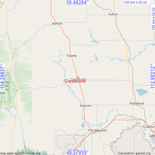
Claresholm GPS coordinates[2]
50° 1' 59.952" North, 113° 35' 6.864" West
| Map corner | latitude | longitude |
|---|---|---|
| Upper-left | 50.48284°, | -114.28837° |
| Center: | 50.03332°, | -113.58524° |
| Lower-right: | 49.57955°, | -112.88212° |
| Map W x H: | 100.4×100.4 km | = 62.4×62.4mi |
| max Lat: | 73.03752° ⇑24.1% North |
| Claresholm: | 50.03332° |
| min Lat: | ⇓75.9% South 42.05009° |
| min Long | Claresholm | max Long |
| -139.43328° | -113.58524° | -52.70931° |
| W 20.1%⇐ | ⇒79.9% E |
Elevation
Elevation of Claresholm is 1034 m = 3392 ft, and this is 779.6 m = 2558 ft above average elevation for this country.
| Max E: |
1518 m = 4980 ft | 2.1% |
| Claresholm | 1034 m 3392 ft | |
| Avg. | 254.4 m = 835 ft | |
Min E: |
-2 m = -7 ft | 97.9% |
See also: Canada elevation on elevation.city.
Geographical zone
Claresholm is located in North temperate zone (between Tropic of Cancer and the Arctic Circle). Distance of this North polar circle is 1838 km =1142.1 mi to North.| Distance of | km | miles | from Claresholm |
|---|---|---|---|
| North Pole | 4443.9 | 2761.3 | to North |
| Arctic Circle | 1838 | 1142.1 | to North |
| Tropic Cancer | 2957.3 | 1837.6 | to South |
| Equator | 5563.2 | 3456.8 | to South |


Nearby cities:
15 places around Claresholm: (largest is in red/bold)
• Black Diamond
87.3 km =54.2 mi,  328°
328°
• Coaldale
77.7 km =48.3 mi,  116°
116°
• Coalhurst
56.6 km =35.2 mi, 124°
• Elkford
92.9 km =57.7 mi,  271°
271°
• Fort Macleod
37.2 km =23.1 mi,  161°
161°
• Heritage Pointe
94.7 km =58.8 mi,  341°
341°
• High River
64.4 km =40 mi, 341°
• Lethbridge
66.3 km =41.2 mi, 124°
• Magrath
85.8 km =53.3 mi,  143°
143°
• Nanton
37.6 km =23.4 mi, 339°
• Okotoks
82.3 km =51.1 mi, 339°
• Picture Butte
59.6 km =37 mi,  106°
106°
• Pincher Creek
66.6 km =41.4 mi,  203°
203°
• Raymond
93.3 km =58 mi,  134°
134°
• Vulcan
47.2 km =29.3 mi,  30°
30°
Sources, notices
• [Note1] Compared only with cities in Canada existing in our database
• [Src1] Map data: © OpenStreetMap contributors (CC-BY-SA)
• [Src2] Other city data from geonames.org with taken over terms of usage.
• [Src3] Geographical zone / Annual Mean Temperature by Robert A. Rohde @ Wikipedia
