Sion geodata
Sion (British Columbia) is a populated place; located in Canada in America/Vancouver (GMT-7) time zone. With population of 658 people, there are 1129 cities with bigger population in this country. Compared to other cities in Canada, 62.1% of cities are located further ↓South; 86.5% of cities are located further →East and 85.2% of cities have lower elevation than Sion. Note1
Administrative division(s):
- Level 1: British Columbia
- Level 2: Regional District of Kootenay-Boundary


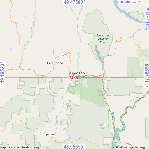
Sion GPS coordinates[2]
49° 1' 0.552" North, 118° 29' 31.56" West
| Map corner | latitude | longitude |
|---|---|---|
| Upper-left | 49.47582°, | -119.19523° |
| Center: | 49.01682°, | -118.4921° |
| Lower-right: | 48.55355°, | -117.78898° |
| Map W x H: | 102.5×102.5 km | = 63.7×63.7mi |
| max Lat: | 73.03752° ⇑37.9% North |
| Sion: | 49.01682° |
| min Lat: | ⇓62.1% South 42.05009° |
| min Long | Sion | max Long |
| -139.43328° | -118.4921° | -52.70931° |
| W 13.5%⇐ | ⇒86.5% E |
Elevation
Elevation of Sion is 575 m = 1886 ft, and this is 320.6 m = 1052 ft above average elevation for this country.
| Max E: |
1518 m = 4980 ft | 14.8% |
| Sion | 575 m 1886 ft | |
| Avg. | 254.4 m = 835 ft | |
Min E: |
-2 m = -7 ft | 85.2% |
See also: Canada elevation on elevation.city.
Geographical zone
Sion is located in North temperate zone (between Tropic of Cancer and the Arctic Circle). Distance of this North polar circle is 1951 km =1212.3 mi to North.| Distance of | km | miles | from Sion |
|---|---|---|---|
| North Pole | 4556.9 | 2831.5 | to North |
| Arctic Circle | 1951 | 1212.3 | to North |
| Tropic Cancer | 2844.2 | 1767.3 | to South |
| Equator | 5450.2 | 3386.6 | to South |


Nearby cities:
15 places around Sion: (largest is in red/bold)
• Castlegar
69.5 km =43.2 mi,  60°
60°
• Ellison
120 km =74.6 mi,  328°
328°
• Fruitvale
69.4 km =43.1 mi,  80°
80°
• Grand Forks
4.5 km =2.8 mi,  66°
66°
• Kelowna
120.1 km =74.6 mi,  323°
323°
• Nelson
102.7 km =63.8 mi, 58°
• Okanagan Falls
86.4 km =53.7 mi,  295°
295°
• Oliver
79.4 km =49.3 mi,  283°
283°
• Osoyoos
70 km =43.5 mi,  271°
271°
• Peachland
122.7 km =76.2 mi,  312°
312°
• Penticton
94.7 km =58.8 mi, 303°
• Rossland
50.8 km =31.6 mi, 81°
• Salmo
91.3 km =56.7 mi, 77°
• Summerland
107.2 km =66.6 mi, 307°
• Trail
58.3 km =36.2 mi, 80°
Sources, notices
• [Note1] Compared only with cities in Canada existing in our database
• [Src1] Map data: © OpenStreetMap contributors (CC-BY-SA)
• [Src2] Other city data from geonames.org with taken over terms of usage.
• [Src3] Geographical zone / Annual Mean Temperature by Robert A. Rohde @ Wikipedia
