Orangeville geodata
Orangeville (Ontario) is a populated place; located in Canada in America/Toronto (GMT-4) time zone. With population of 30,734 people, there are 144 cities with bigger population in this country. Compared to other cities in Canada, 92.2% of cities are located further ↑North; 55.8% of cities are located further →East and 79.9% of cities have lower elevation than Orangeville. Note1


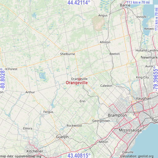
Orangeville GPS coordinates[2]
43° 55' 0.48" North, 80° 5' 58.812" West
| Map corner | latitude | longitude |
|---|---|---|
| Upper-left | 44.42114°, | -80.8028° |
| Center: | 43.9168°, | -80.09967° |
| Lower-right: | 43.40815°, | -79.39655° |
| Map W x H: | 112.6×112.6 km | = 70×70mi |
| max Lat: | 73.03752° ⇑92.2% North |
| Orangeville: | 43.9168° |
| min Lat: | ⇓7.8% South 42.05009° |
| min Long | Orangeville | max Long |
| -139.43328° | -80.09967° | -52.70931° |
| W 44.2%⇐ | ⇒55.8% E |
Elevation
Elevation of Orangeville is 443 m = 1453 ft, and this is 188.6 m = 619 ft above average elevation for this country.
| Max E: |
1518 m = 4980 ft | 20.1% |
| Orangeville | 443 m 1453 ft | |
| Avg. | 254.4 m = 835 ft | |
Min E: |
-2 m = -7 ft | 79.9% |
See also: Canada elevation on elevation.city.
Geographical zone
Orangeville is located in North temperate zone (between Tropic of Cancer and the Arctic Circle). Distance of this Northern Tropic circle is 2277.2 km =1415 mi to South.| Distance of | km | miles | from Orangeville |
|---|---|---|---|
| North Pole | 5124 | 3183.9 | to North |
| Arctic Circle | 2518.1 | 1564.7 | to North |
| Tropic Cancer | 2277.2 | 1415 | to South |
| Equator | 4883.1 | 3034.2 | to South |


Nearby cities:
15 places around Orangeville: (largest is in red/bold)
• Alliston
32 km =19.9 mi,  35°
35°
• Angus
47.7 km =29.6 mi,  21°
21°
• Aurora
51.5 km =32 mi,  79°
79°
• Brampton
37.3 km =23.2 mi,  134°
134°
• Concord
51.1 km =31.8 mi,  104°
104°
• Cookstown
43.6 km =27.1 mi,  47°
47°
• Etobicoke
51.8 km =32.2 mi,  124°
124°
• Guelph
43.1 km =26.8 mi,  196°
196°
• King
41.1 km =25.5 mi, 82°
• Milton
47.8 km =29.7 mi,  158°
158°
• Mississauga
51.7 km =32.1 mi,  136°
136°
• Rockwood
33.3 km =20.7 mi,  186°
186°
• Shelburne
19.8 km =12.3 mi,  335°
335°
• Tottenham
26.4 km =16.4 mi,  63°
63°
• Vaughan
49 km =30.4 mi, 100°
Sources, notices
• [Note1] Compared only with cities in Canada existing in our database
• [Src1] Map data: © OpenStreetMap contributors (CC-BY-SA)
• [Src2] Other city data from geonames.org with taken over terms of usage.
• [Src3] Geographical zone / Annual Mean Temperature by Robert A. Rohde @ Wikipedia
