Oxford geodata
Oxford (Nova Scotia) is a populated place; located in Canada in America/Halifax (GMT-3) time zone. With population of 1,283 people, there are 927 cities with bigger population in this country. Compared to other cities in Canada, 68.5% of cities are located further ↑North; 94.1% of cities are located further ←West and 96.5% of cities have higher elevation than Oxford. Note1


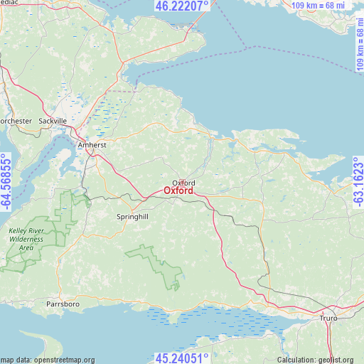
Oxford GPS coordinates[2]
45° 44' 0.42" North, 63° 51' 55.512" West
| Map corner | latitude | longitude |
|---|---|---|
| Upper-left | 46.22207°, | -64.56855° |
| Center: | 45.73345°, | -63.86542° |
| Lower-right: | 45.24051°, | -63.1623° |
| Map W x H: | 109.1×109.1 km | = 67.8×67.8mi |
| max Lat: | 73.03752° ⇑68.5% North |
| Oxford: | 45.73345° |
| min Lat: | ⇓31.5% South 42.05009° |
| min Long | Oxford | max Long |
| -139.43328° | -63.86542° | -52.70931° |
| W 94.1%⇐ | ⇒5.9% E |
Elevation
Elevation of Oxford is 6 m = 20 ft, and this is 248.4 m = 815 ft below average elevation for this country.
| Max E: |
1518 m = 4980 ft | 96.5% |
| Avg. | 254.4 m = 835 ft | |
| Oxford | 6 m = 20 ft | |
Min E: |
-2 m = -7 ft | 3.5% |
See also: Canada elevation on elevation.city.
Geographical zone
Oxford is located in North temperate zone (between Tropic of Cancer and the Arctic Circle). Distance of this North polar circle is 2316.1 km =1439.2 mi to North.| Distance of | km | miles | from Oxford |
|---|---|---|---|
| North Pole | 4922 | 3058.4 | to North |
| Arctic Circle | 2316.1 | 1439.2 | to North |
| Tropic Cancer | 2479.2 | 1540.5 | to South |
| Equator | 5085.1 | 3159.7 | to South |


Nearby cities:
15 places around Oxford: (largest is in red/bold)
• Amherst
28.1 km =17.5 mi,  293°
293°
• Cornwall
74.2 km =46.1 mi,  42°
42°
• Dieppe
74.3 km =46.2 mi,  301°
301°
• Greater Lakeburn
72.9 km =45.3 mi, 301°
• Hantsport
77.7 km =48.3 mi,  197°
197°
• Haute-Aboujagane
61.9 km =38.5 mi,  318°
318°
• Middleton
53.3 km =33.1 mi,  92°
92°
• Parrsboro
51.1 km =31.8 mi,  224°
224°
• Point de Bute
34.6 km =21.5 mi, 302°
• Sackville
45.2 km =28.1 mi, 297°
• Shediac
75.2 km =46.7 mi, 316°
• Shediac Cape
77.6 km =48.2 mi, 315°
• Springhill
17 km =10.6 mi,  236°
236°
• Summerside
73.9 km =45.9 mi,  4°
4°
• Truro
62 km =38.5 mi,  131°
131°
Sources, notices
• [Note1] Compared only with cities in Canada existing in our database
• [Src1] Map data: © OpenStreetMap contributors (CC-BY-SA)
• [Src2] Other city data from geonames.org with taken over terms of usage.
• [Src3] Geographical zone / Annual Mean Temperature by Robert A. Rohde @ Wikipedia
