Amherst geodata
Amherst (Nova Scotia) is a populated place; located in Canada in America/Halifax (GMT-3) time zone. With population of 9,336 people, there are 329 cities with bigger population in this country. Compared to other cities in Canada, 67.2% of cities are located further ↑North; 93.5% of cities are located further ←West and 85.9% of cities have higher elevation than Amherst. Note1


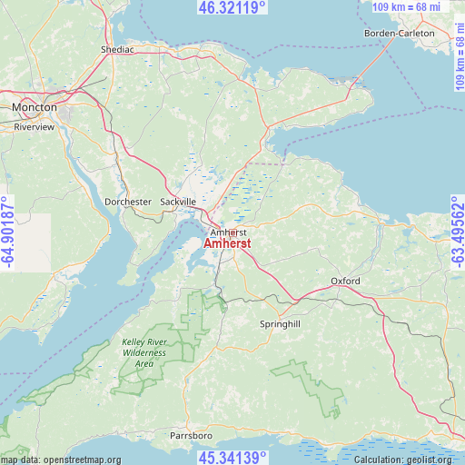
Amherst GPS coordinates[2]
45° 50' 0.42" North, 64° 11' 55.464" West
| Map corner | latitude | longitude |
|---|---|---|
| Upper-left | 46.32119°, | -64.90187° |
| Center: | 45.83345°, | -64.19874° |
| Lower-right: | 45.34139°, | -63.49562° |
| Map W x H: | 108.9×108.9 km | = 67.7×67.7mi |
| max Lat: | 73.03752° ⇑67.2% North |
| Amherst: | 45.83345° |
| min Lat: | ⇓32.8% South 42.05009° |
| min Long | Amherst | max Long |
| -139.43328° | -64.19874° | -52.70931° |
| W 93.5%⇐ | ⇒6.5% E |
Elevation
Elevation of Amherst is 20 m = 66 ft, and this is 234.4 m = 769 ft below average elevation for this country.
| Max E: |
1518 m = 4980 ft | 85.9% |
| Avg. | 254.4 m = 835 ft | |
| Amherst | 20 m = 66 ft | |
Min E: |
-2 m = -7 ft | 14.1% |
See also: Canada elevation on elevation.city.
Geographical zone
Amherst is located in North temperate zone (between Tropic of Cancer and the Arctic Circle). Distance of this North polar circle is 2305 km =1432.3 mi to North.| Distance of | km | miles | from Amherst |
|---|---|---|---|
| North Pole | 4910.9 | 3051.5 | to North |
| Arctic Circle | 2305 | 1432.3 | to North |
| Tropic Cancer | 2490.3 | 1547.4 | to South |
| Equator | 5096.2 | 3166.6 | to South |


Nearby cities:
15 places around Amherst: (largest is in red/bold)
• Dieppe
46.6 km =29 mi,  305°
305°
• Evergreen Park
60.1 km =37.3 mi,  301°
301°
• Grande-Digue
59.1 km =36.7 mi,  331°
331°
• Greater Lakeburn
45.2 km =28.1 mi, 306°
• Haute-Aboujagane
38.3 km =23.8 mi,  336°
336°
• McEwen
57.1 km =35.5 mi, 307°
• Moncton
54.6 km =33.9 mi, 302°
• Oxford
28.1 km =17.5 mi,  113°
113°
• Parrsboro
48.6 km =30.2 mi,  191°
191°
• Point de Bute
8.2 km =5.1 mi, 335°
• Sackville
17.2 km =10.7 mi, 303°
• Shediac
50.4 km =31.3 mi, 328°
• Shediac Bridge-Shediac River
57.5 km =35.7 mi, 327°
• Shediac Cape
52.7 km =32.7 mi, 327°
• Springhill
23.5 km =14.6 mi,  150°
150°
Sources, notices
• [Note1] Compared only with cities in Canada existing in our database
• [Src1] Map data: © OpenStreetMap contributors (CC-BY-SA)
• [Src2] Other city data from geonames.org with taken over terms of usage.
• [Src3] Geographical zone / Annual Mean Temperature by Robert A. Rohde @ Wikipedia
