Penhold geodata
Penhold (Alberta) is a populated place; located in Canada in America/Edmonton (GMT-6) time zone. With population of 1,818 people, there are 788 cities with bigger population in this country. Compared to other cities in Canada, 86.3% of cities are located further ↓South; 80.9% of cities are located further →East and 95.8% of cities have lower elevation than Penhold. Note1


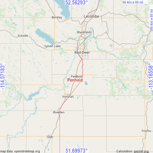
Penhold GPS coordinates[2]
52° 8' 0.312" North, 113° 52' 7.32" West
| Map corner | latitude | longitude |
|---|---|---|
| Upper-left | 52.56293°, | -114.57183° |
| Center: | 52.13342°, | -113.8687° |
| Lower-right: | 51.69973°, | -113.16558° |
| Map W x H: | 96×96 km | = 59.7×59.7mi |
| max Lat: | 73.03752° ⇑13.7% North |
| Penhold: | 52.13342° |
| min Lat: | ⇓86.3% South 42.05009° |
| min Long | Penhold | max Long |
| -139.43328° | -113.8687° | -52.70931° |
| W 19.1%⇐ | ⇒80.9% E |
Elevation
Elevation of Penhold is 895 m = 2936 ft, and this is 640.6 m = 2102 ft above average elevation for this country.
| Max E: |
1518 m = 4980 ft | 4.2% |
| Penhold | 895 m 2936 ft | |
| Avg. | 254.4 m = 835 ft | |
Min E: |
-2 m = -7 ft | 95.8% |
See also: Canada elevation on elevation.city.
Geographical zone
Penhold is located in North temperate zone (between Tropic of Cancer and the Arctic Circle). Distance of this North polar circle is 1604.5 km =997 mi to North.| Distance of | km | miles | from Penhold |
|---|---|---|---|
| North Pole | 4210.4 | 2616.2 | to North |
| Arctic Circle | 1604.5 | 997 | to North |
| Tropic Cancer | 3190.8 | 1982.7 | to South |
| Equator | 5796.7 | 3601.9 | to South |


Nearby cities:
15 places around Penhold: (largest is in red/bold)
• Blackfalds
28.4 km =17.6 mi,  11°
11°
• Carstairs
65 km =40.4 mi,  194°
194°
• Crossfield
78.7 km =48.9 mi, 188°
• Didsbury
55 km =34.2 mi,  199°
199°
• Lacombe
38.2 km =23.7 mi, 13°
• Olds
42.1 km =26.2 mi, 202°
• Ponoka
63.5 km =39.5 mi,  17°
17°
• Red Deer
15.5 km =9.6 mi, 17°
• Rimbey
60.9 km =37.8 mi,  335°
335°
• Rocky Mountain House
76 km =47.2 mi,  289°
289°
• Springbrook
5.1 km =3.2 mi,  351°
351°
• Stettler
80.9 km =50.3 mi,  75°
75°
• Sundre
64.3 km =40 mi,  234°
234°
• Sylvan Lake
24.6 km =15.3 mi,  323°
323°
• Three Hills
63.4 km =39.4 mi,  139°
139°
Sources, notices
• [Note1] Compared only with cities in Canada existing in our database
• [Src1] Map data: © OpenStreetMap contributors (CC-BY-SA)
• [Src2] Other city data from geonames.org with taken over terms of usage.
• [Src3] Geographical zone / Annual Mean Temperature by Robert A. Rohde @ Wikipedia
