Rimbey geodata
Rimbey (Alberta) is a populated place; located in Canada in America/Edmonton (GMT-6) time zone. With population of 2,227 people, there are 713 cities with bigger population in this country. Compared to other cities in Canada, 88% of cities are located further ↓South; 82.2% of cities are located further →East and 96.2% of cities have lower elevation than Rimbey. Note1


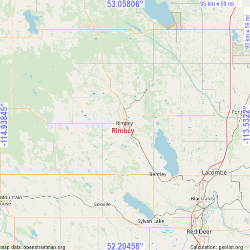
Rimbey GPS coordinates[2]
52° 38' 0.24" North, 114° 14' 7.152" West
| Map corner | latitude | longitude |
|---|---|---|
| Upper-left | 53.05806°, | -114.93845° |
| Center: | 52.6334°, | -114.23532° |
| Lower-right: | 52.20458°, | -113.5322° |
| Map W x H: | 94.9×94.9 km | = 59×59mi |
| max Lat: | 73.03752° ⇑12% North |
| Rimbey: | 52.6334° |
| min Lat: | ⇓88% South 42.05009° |
| min Long | Rimbey | max Long |
| -139.43328° | -114.23532° | -52.70931° |
| W 17.8%⇐ | ⇒82.2% E |
Elevation
Elevation of Rimbey is 913 m = 2995 ft, and this is 658.6 m = 2161 ft above average elevation for this country.
| Max E: |
1518 m = 4980 ft | 3.8% |
| Rimbey | 913 m 2995 ft | |
| Avg. | 254.4 m = 835 ft | |
Min E: |
-2 m = -7 ft | 96.2% |
See also: Canada elevation on elevation.city.
Geographical zone
Rimbey is located in North temperate zone (between Tropic of Cancer and the Arctic Circle). Distance of this North polar circle is 1548.9 km =962.4 mi to North.| Distance of | km | miles | from Rimbey |
|---|---|---|---|
| North Pole | 4154.8 | 2581.7 | to North |
| Arctic Circle | 1548.9 | 962.4 | to North |
| Tropic Cancer | 3246.4 | 2017.2 | to South |
| Equator | 5852.3 | 3636.4 | to South |


Nearby cities:
15 places around Rimbey: (largest is in red/bold)
• Blackfalds
41.2 km =25.6 mi,  132°
132°
• Calmar
75.8 km =47.1 mi,  21°
21°
• Devon
88.1 km =54.7 mi, 22°
• Drayton Valley
82.1 km =51 mi,  322°
322°
• Lacombe
38.5 km =23.9 mi,  118°
118°
• Leduc
84 km =52.2 mi,  33°
33°
• Millet
73.1 km =45.4 mi,  44°
44°
• Olds
94.9 km =59 mi,  174°
174°
• Penhold
60.9 km =37.8 mi,  155°
155°
• Ponoka
44.4 km =27.6 mi,  83°
83°
• Red Deer
50.2 km =31.2 mi,  144°
144°
• Rocky Mountain House
54.9 km =34.1 mi,  237°
237°
• Springbrook
56 km =34.8 mi,  154°
154°
• Sylvan Lake
37.3 km =23.2 mi, 164°
• Wetaskiwin
69.1 km =42.9 mi,  57°
57°
Sources, notices
• [Note1] Compared only with cities in Canada existing in our database
• [Src1] Map data: © OpenStreetMap contributors (CC-BY-SA)
• [Src2] Other city data from geonames.org with taken over terms of usage.
• [Src3] Geographical zone / Annual Mean Temperature by Robert A. Rohde @ Wikipedia
