Red Deer geodata
Red Deer (Alberta) is a populated place; located in Canada in America/Edmonton (GMT-6) time zone. With population of 73,593 people, there are 75 cities with bigger population in this country. Compared to other cities in Canada, 86.9% of cities are located further ↓South; 80.6% of cities are located further →East and 95.5% of cities have lower elevation than Red Deer. Note1


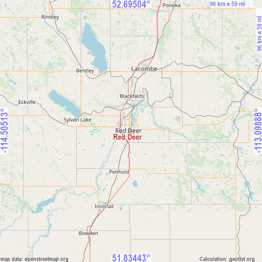
Red Deer GPS coordinates[2]
52° 16' 0.552" North, 113° 48' 7.2" West
| Map corner | latitude | longitude |
|---|---|---|
| Upper-left | 52.69504°, | -114.50513° |
| Center: | 52.26682°, | -113.802° |
| Lower-right: | 51.83443°, | -113.09888° |
| Map W x H: | 95.7×95.7 km | = 59.5×59.5mi |
| max Lat: | 73.03752° ⇑13.1% North |
| Red Deer: | 52.26682° |
| min Lat: | ⇓86.9% South 42.05009° |
| min Long | Red Deer | max Long |
| -139.43328° | -113.802° | -52.70931° |
| W 19.4%⇐ | ⇒80.6% E |
Elevation
Elevation of Red Deer is 856 m = 2808 ft, and this is 601.6 m = 1974 ft above average elevation for this country.
| Max E: |
1518 m = 4980 ft | 4.5% |
| Red Deer | 856 m 2808 ft | |
| Avg. | 254.4 m = 835 ft | |
Min E: |
-2 m = -7 ft | 95.5% |
See also: Red Deer elevation on elevation.city.
Geographical zone
Red Deer is located in North temperate zone (between Tropic of Cancer and the Arctic Circle). Distance of this North polar circle is 1589.6 km =987.7 mi to North.| Distance of | km | miles | from Red Deer |
|---|---|---|---|
| North Pole | 4195.5 | 2607 | to North |
| Arctic Circle | 1589.6 | 987.7 | to North |
| Tropic Cancer | 3205.6 | 1991.9 | to South |
| Equator | 5811.5 | 3611.1 | to South |


Nearby cities:
15 places around Red Deer: (largest is in red/bold)
• Blackfalds
13 km =8.1 mi,  5°
5°
• Carstairs
80.5 km =50 mi,  194°
194°
• Didsbury
70.5 km =43.8 mi,  198°
198°
• Lacombe
22.7 km =14.1 mi, 11°
• Olds
57.5 km =35.7 mi, 200°
• Penhold
15.5 km =9.6 mi, 197°
• Ponoka
48 km =29.8 mi,  18°
18°
• Rimbey
50.2 km =31.2 mi,  324°
324°
• Rocky Mountain House
76.7 km =47.7 mi,  278°
278°
• Springbrook
11.1 km =6.9 mi,  208°
208°
• Stettler
73.9 km =45.9 mi,  85°
85°
• Sundre
77.1 km =47.9 mi,  227°
227°
• Sylvan Lake
19.8 km =12.3 mi, 284°
• Three Hills
72.8 km =45.2 mi,  149°
149°
• Wetaskiwin
83.1 km =51.6 mi, 20°
Sources, notices
• [Note1] Compared only with cities in Canada existing in our database
• [Src1] Map data: © OpenStreetMap contributors (CC-BY-SA)
• [Src2] Other city data from geonames.org with taken over terms of usage.
• [Src3] Geographical zone / Annual Mean Temperature by Robert A. Rohde @ Wikipedia
