Stettler geodata
Stettler (Alberta) is a populated place; located in Canada in America/Edmonton (GMT-6) time zone. With population of 5,494 people, there are 453 cities with bigger population in this country. Compared to other cities in Canada, 87.2% of cities are located further ↓South; 77.3% of cities are located further →East and 94.9% of cities have lower elevation than Stettler. Note1


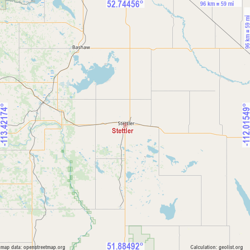
Stettler GPS coordinates[2]
52° 19' 0.588" North, 112° 43' 6.996" West
| Map corner | latitude | longitude |
|---|---|---|
| Upper-left | 52.74456°, | -113.42174° |
| Center: | 52.31683°, | -112.71861° |
| Lower-right: | 51.88492°, | -112.01549° |
| Map W x H: | 95.6×95.6 km | = 59.4×59.4mi |
| max Lat: | 73.03752° ⇑12.8% North |
| Stettler: | 52.31683° |
| min Lat: | ⇓87.2% South 42.05009° |
| min Long | Stettler | max Long |
| -139.43328° | -112.71861° | -52.70931° |
| W 22.7%⇐ | ⇒77.3% E |
Elevation
Elevation of Stettler is 814 m = 2671 ft, and this is 559.6 m = 1836 ft above average elevation for this country.
| Max E: |
1518 m = 4980 ft | 5.1% |
| Stettler | 814 m 2671 ft | |
| Avg. | 254.4 m = 835 ft | |
Min E: |
-2 m = -7 ft | 94.9% |
See also: Canada elevation on elevation.city.
Geographical zone
Stettler is located in North temperate zone (between Tropic of Cancer and the Arctic Circle). Distance of this North polar circle is 1584.1 km =984.3 mi to North.| Distance of | km | miles | from Stettler |
|---|---|---|---|
| North Pole | 4190 | 2603.5 | to North |
| Arctic Circle | 1584.1 | 984.3 | to North |
| Tropic Cancer | 3211.2 | 1995.3 | to South |
| Equator | 5817.1 | 3614.6 | to South |


Nearby cities:
15 places around Stettler: (largest is in red/bold)
• Blackfalds
72.8 km =45.2 mi,  275°
275°
• Camrose
78.2 km =48.6 mi,  354°
354°
• Hanna
94.4 km =58.7 mi,  143°
143°
• Killam
78.3 km =48.7 mi,  48°
48°
• Lacombe
71 km =44.1 mi, 283°
• Millet
100.7 km =62.6 mi,  329°
329°
• Penhold
80.9 km =50.3 mi,  255°
255°
• Ponoka
70.8 km =44 mi,  304°
304°
• Red Deer
73.9 km =45.9 mi,  265°
265°
• Rimbey
108.6 km =67.5 mi,  288°
288°
• Springbrook
80.5 km =50 mi, 259°
• Sylvan Lake
92.8 km =57.7 mi, 269°
• Three Hills
78.2 km =48.6 mi,  208°
208°
• Viking
108.1 km =67.2 mi,  36°
36°
• Wetaskiwin
84.5 km =52.5 mi, 328°
Sources, notices
• [Note1] Compared only with cities in Canada existing in our database
• [Src1] Map data: © OpenStreetMap contributors (CC-BY-SA)
• [Src2] Other city data from geonames.org with taken over terms of usage.
• [Src3] Geographical zone / Annual Mean Temperature by Robert A. Rohde @ Wikipedia
